|
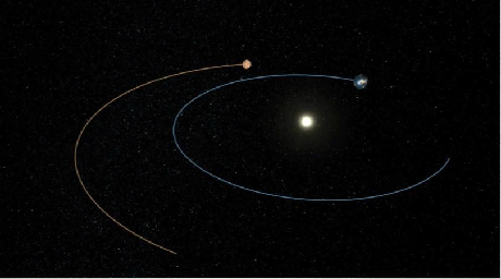
Phoenix’s Path to Mars (Artist’s Concept)
- Click the image above for a larger view
 Movie Download Options
- Full-Res JPEG (810 x 451) (32.5 kB)
- Full-Res TIFF (810 x 451) (1.1 MB)
Caption:

Click on the image for movie of
Phoenix's Path to Mars
This artist's animation shows the route NASA's Phoenix Mars Lander took to get from Earth to Mars. The spacecraft's path is shown in yellow, and the orbits of Mars and Earth are shown in red and blue, respectively.
Phoenix was launched from Cape Canaveral Air Force Station, Fla., on Aug. 4, 2007, when Earth and Mars were 195 million kilometers (121 million miles) apart. It will have traveled a total of 679 million kilometers (422 million miles) when it is scheduled to reach Mars on May 25, 2008. At that time, Earth and Mars will be farther apart, at 276 million kilometers (171 million miles).
Background Info:
The Phoenix Mission is led by the University of Arizona, Tucson, on behalf of NASA. Project management of the mission is by NASA's Jet Propulsion Laboratory, Pasadena, Calif. Spacecraft development is by Lockheed Martin Space Systems, Denver.
Photojournal Note: As planned, the Phoenix lander, which landed May 25, 2008 23:53 UTC, ended communications in November 2008, about six months after landing, when its solar panels ceased operating in the dark Martian winter.
Cataloging Keywords:
| Name | Value | Additional Values |
|---|---|---|
| Target | Mars | |
| System | ||
| Target Type | Planet | |
| Mission | Phoenix | |
| Instrument Host | Phoenix Lander | |
| Host Type | Lander | |
| Instrument | ||
| Detector | ||
| Extra Keywords | Artwork, Color, Movie | |
| Acquisition Date | ||
| Release Date | 2008-05-22 | |
| Date in Caption | 2007-08-04 | 2008-05-25 |
| Image Credit | NASA/JPL-Caltech/University of Arizona | |
| Source | photojournal.jpl.nasa.gov/catalog/PIA10667 | |
| Identifier | PIA10667 | |
