|
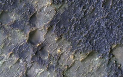
Contact between Two Distinct Types of Bedrock Northwest of Hellas Planitia
- Click the image above for a larger view
- Full-Res JPEG (2880 x 1800) (998.8 kB)
- Full-Res TIFF (2880 x 1800) (15.6 MB)
Caption:

Map Projected Browse Image
Click on the image for larger version
In this context image is an old degraded crater that has undergone a complex history of burial and erosion. The image shows a surface with at least two types of exposed bedrock, one that is light-toned and one that is dark. An enhanced color infrared image highlights these two exposures in yellows and blues, which such colors representing altered and unaltered surfaces, respectively.
The overlying, rougher blueish-toned bedrock appears to have undergone the most extensive erosion, revealing the smoother, fractured yellowish-toned bedrock below. We see windblown (aeolian) bedforms across the image, possibly the culprit behind the erosive forces that have removed and uncovered the underlying yellowish-toned bedrock visible today.
Background Info:
The University of Arizona, Tucson, operates HiRISE, which was built by Ball Aerospace & Technologies Corp., Boulder, Colo. NASA's Jet Propulsion Laboratory, a division of Caltech in Pasadena, California, manages the Mars Reconnaissance Orbiter Project for NASA's Science Mission Directorate, Washington.
Cataloging Keywords:
| Name | Value | Additional Values |
|---|---|---|
| Target | Mars | |
| System | ||
| Target Type | Planet | |
| Mission | Mars Reconnaissance Orbiter (MRO) | |
| Instrument Host | Mars Reconnaissance Orbiter | |
| Host Type | Orbiter | |
| Instrument | High Resolution Imaging Science Experiment (HiRISE) | |
| Detector | ||
| Extra Keywords | Color, Crater, Infrared, Map | |
| Acquisition Date | ||
| Release Date | 2017-01-25 | |
| Date in Caption | ||
| Image Credit | NASA/JPL-Caltech/Univ. of Arizona | |
| Source | photojournal.jpl.nasa.gov/catalog/PIA11705 | |
| Identifier | PIA11705 | |
