|
NASA’s Moon Mineralogy Mapper
- Click the image above for a larger view
- Full-Res JPEG (631 x 635) (65.6 kB)
- Full-Res TIFF (631 x 635) (1.2 MB)
Caption:
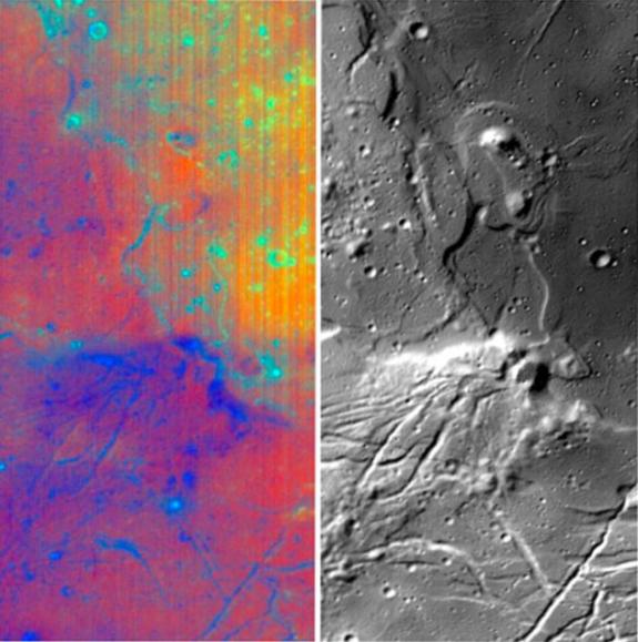
Different wavelengths of light provide new information about the Orientale Basin region of the moon in a composite image taken by NASA's Moon Mineralogy Mapper, a guest instrument aboard the Indian Space Research Organization's Chandrayaan-1 spacecraft.
The composite image consists of a subset of Moon Mineralogy Mapper data for the Orientale region. The image strip on the left is a color composite of data from 28 separate wavelengths of light reflected from the moon. The blue to red tones reveal changes in rock and mineral composition, and the green color is an indication of the abundance of iron-bearing minerals such as pyroxene. The image strip on the right is from a single wavelength of light that contains thermal emission, providing a new level of detail on the form and structure of the region's surface.
The Moon Mineralogy Mapper provides scientists their first opportunity to examine lunar mineralogy at high spatial and spectral resolution.
The Orientale Basin is located on the moon's western limb. The data for this composite were captured by the Moon Mineralogy Mapper during the commissioning phase of Chandrayaan-1 as the spacecraft orbited the moon at an altitude of 100 kilometers (62 miles).
Background Info:
More information about NASA's Moon Mineralogy Mapper Instrument can be found at: http://m3.jpl.nasa.gov .
Cataloging Keywords:
| Name | Value | Additional Values |
|---|---|---|
| Target | Moon | |
| System | Earth | |
| Target Type | Satellite | |
| Mission | Chandrayaan-1 | |
| Instrument Host | Chandrayaan-1 | |
| Host Type | ||
| Instrument | Moon Mineralogy Mapper | |
| Detector | ||
| Extra Keywords | Color, Thermal | |
| Acquisition Date | ||
| Release Date | 2008-12-17 | |
| Date in Caption | ||
| Image Credit | NASA/JPL/Brown | |
| Source | photojournal.jpl.nasa.gov/catalog/PIA11727 | |
| Identifier | PIA11727 | |