|
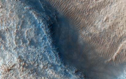
Fill or Mantling Material in a Crater
- Click the image above for a larger view
- Full-Res JPEG (2880 x 1800) (1.1 MB)
- Full-Res TIFF (2880 x 1800) (15.6 MB)
Caption:

Map Projected Browse Image
Click on the image for larger version
This observation targets some unknown fill or mantling material within valleys on a crater floor and within a central pit.
High resolution imagery can help determine what this material may be (e.g., ice-rich fill, dust, or other mantling unit?) and estimates of its thickness . With knowledge of its thickness, we can discern how deep the valleys and pit would be without its presence. This is necessary information, because without knowing the thickness of the material, appropriate discharge values for the valleys cannot be determined and neither can the history of the crater prior to infill.
This caption is based on the original science rationale.
Background Info:
The University of Arizona, Tucson, operates HiRISE, which was built by Ball Aerospace & Technologies Corp., Boulder, Colorado. NASA's Jet Propulsion Laboratory, a division of the California Institute of Technology in Pasadena, manages the Mars Reconnaissance Orbiter Project and Mars Science Laboratory Project for NASA's Science Mission Directorate, Washington.
Cataloging Keywords:
| Name | Value | Additional Values |
|---|---|---|
| Target | Mars | |
| System | ||
| Target Type | Planet | |
| Mission | Mars Reconnaissance Orbiter (MRO) | Mars Science Laboratory (MSL) |
| Instrument Host | Mars Reconnaissance Orbiter | Curiosity Rover |
| Host Type | Orbiter | Rover |
| Instrument | High Resolution Imaging Science Experiment (HiRISE) | |
| Detector | ||
| Extra Keywords | Color, Crater, Dust, Map | |
| Acquisition Date | ||
| Release Date | 2015-06-03 | |
| Date in Caption | ||
| Image Credit | NASA/JPL-Caltech/Univ. of Arizona | |
| Source | photojournal.jpl.nasa.gov/catalog/PIA11775 | |
| Identifier | PIA11775 | |
