
|
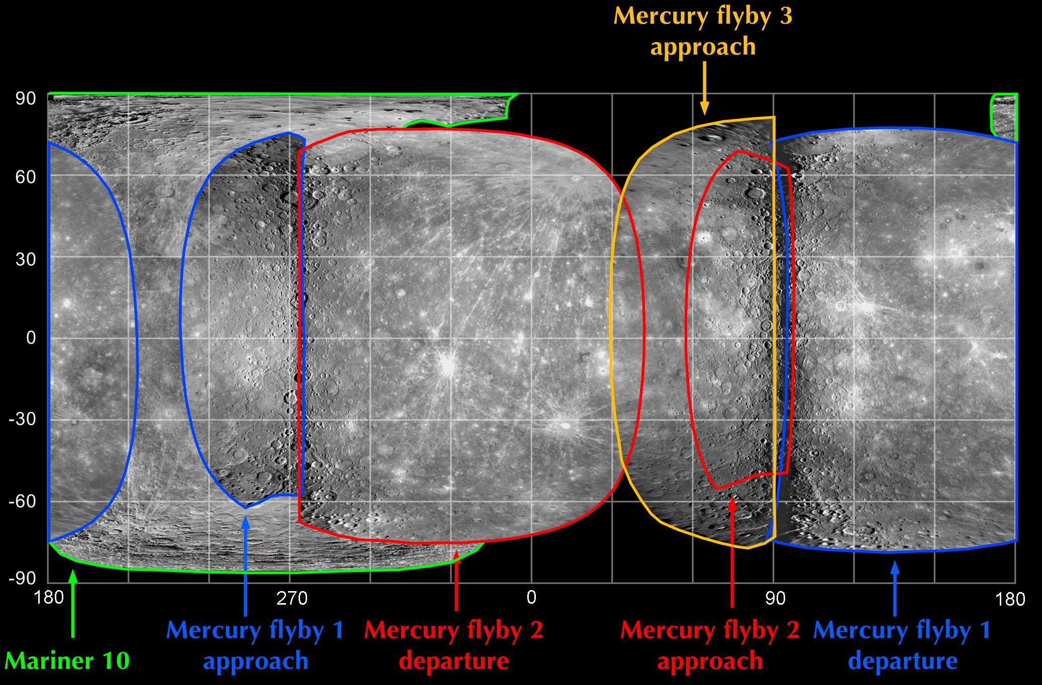
A Global Map of Mercury’s Surface
- Click the image above for a larger view
- Full-Res JPEG (2073 x 1364) (460.8 kB)
- Full-Res TIFF (2073 x 1364) (8.5 MB)
Caption:
One of the main science imaging goals of MESSENGER's third Mercury flyby was to obtain the first images of a portion of Mercury's surface that had never before been seen by spacecraft. That goal has now been successfully achieved, as shown in the imaging coverage map here. The images obtained as the spacecraft approached the planet for the mission's third Mercury flyby three days ago (outlined in yellow) filled a gap in the map that existed prior to the encounter . Combining the new Mercury flyby 3 coverage with photos obtained from Mariner 10's three flybys in 1974-75 (outlined in green) and images from MESSENGER's first (outlined in blue) and second (outlined in red) Mercury encounters in 2008 now yields nearly total coverage of Mercury's surface with the exception of the polar regions at latitudes above 60° N or below -60° S. Along with revealing intriguing geologic features in this previously unseen terrain, having a complete global map of Mercury's surface, free of gaps, will be valuable for planning MESSENGER's orbital operations, which will begin in March 2011.
Date of Mercury Flyby 3:
September 29, 2009
Date of Mercury Flyby 2:
October 6, 2008
Date of Mercury Flyby 1:
January 14, 2008
Instrument:
Narrow Angle Camera (NAC) of the Mercury Dual Imaging System (MDIS)
Scale:
Mercury's diameter is 4880 kilometers (3030 miles)
Background Info:
These images are from MESSENGER, a NASA Discovery mission to conduct the first orbital study of the innermost planet, Mercury. For information regarding the use of images, see the MESSENGER image use policy .
Cataloging Keywords:
| Name | Value | Additional Values |
|---|---|---|
| Target | Mercury | |
| System | ||
| Target Type | Planet | |
| Mission | MESSENGER | Mariner |
| Instrument Host | MESSENGER | Mariner 10 |
| Host Type | Orbiter | Flyby Spacecraft |
| Instrument | Mercury Dual Imaging System (MDIS) | |
| Detector | Narrow Angle Camera (NAC) | |
| Extra Keywords | Color, Map | |
| Acquisition Date | ||
| Release Date | 2009-10-02 | |
| Date in Caption | 2008-01-14 | 2008-10-06, 2009-09-29 |
| Image Credit | NASA/Johns Hopkins University Applied Physics Laboratory/Carnegie Institution of Washington | |
| Source | photojournal.jpl.nasa.gov/catalog/PIA12278 | |
| Identifier | PIA12278 | |