|
Changing Seasons on Titan
- Click the image above for a larger view
- Full-Res JPEG (1224 x 1080) (274.2 kB)
- Full-Res TIFF (1224 x 1080) (4.0 MB)
Caption:
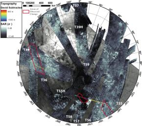
This composite image shows the southern polar area of Saturn's moon Titan, using data from the Synthetic Aperture Radar instrument aboard the Cassini spacecraft. It is radar's first glimpse of seasonal change on the moon. From September 2005 to July 2009, the instrument bounced radar beams off Titan's surface to create images of about 60 percent of the area from 55 degrees south to 90 degrees south in latitude. The instrument took measurements of about 10 percent of this area twice, enabling scientists to see changes on the surface occurring near the end of southern hemisphere summer. In the areas outlined in red, scientists saw lakes inferred to be filled with liquid ethane and methane shrivel or disappear. Ontario Lacus, the largest lake in the southern region, is located in the red bean-shaped outline in the middle. The two other areas are shown in more detail in PIA12281 .
This composite image was presented by Alexander G. Hayes at the Division for Planetary Sciences meeting of the American Astronomical Society on Oct. 6, 2009.
Background Info:
The Cassini-Huygens mission is a cooperative project of NASA, the European Space Agency and the Italian Space Agency. The Jet Propulsion Laboratory, a division of the California Institute of Technology in Pasadena, Calif. manages the mission for NASA's Science Mission Directorate, Washington, D.C.
For more information about the Cassini-Huygens mission visit http://saturn.jpl.nasa.gov .
Cataloging Keywords:
| Name | Value | Additional Values |
|---|---|---|
| Target | Titan | |
| System | Saturn | |
| Target Type | Satellite | |
| Mission | Cassini-Huygens | |
| Instrument Host | Cassini Orbiter | |
| Host Type | Orbiter | |
| Instrument | Radar Mapper | |
| Detector | ||
| Extra Keywords | Color, Methane, Radar | |
| Acquisition Date | ||
| Release Date | 2009-10-09 | |
| Date in Caption | 2009-10-06 | |
| Image Credit | NASA/JPL-Caltech/ASI | |
| Source | photojournal.jpl.nasa.gov/catalog/PIA12280 | |
| Identifier | PIA12280 | |
