|
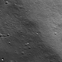
Bouncing, Bounding Boulders!
- Click the image above for a larger view
- Full-Res JPEG (1000 x 1000) (129.7 kB)
- Full-Res TIFF (1000 x 1000) (1.0 MB)
Caption:
Many boulder trails are found on the lunar crater walls and basin massifs. Some of the trails are smooth and nearly straight while others are curvy or gouge into the surface. In many cases by following a boulder's trail you are led back to its point of origin, useful information for a future geologist sampling otherwise unreachable points. Image width is 600-m across, north is up, and the boulder in the lower left-hand corner is 15-m across, unnamed 15-km diamater crater southwest of Rowland crater.
Background Info:
NASA's Goddard Space Flight Center built and manages the mission for the Exploration Systems Mission Directorate at NASA Headquarters in Washington. The Lunar Reconnaissance Orbiter Camera was designed to acquire data for landing site certification and to conduct polar illumination studies and global mapping. Operated by Arizona State University, the LROC facility is part of the School of Earth and Space Exploration (SESE). LROC consists of a pair of narrow-angle cameras (NAC) and a single wide-angle camera (WAC). The mission is expected to return over 70 terabytes of image data.
Cataloging Keywords:
| Name | Value | Additional Values |
|---|---|---|
| Target | Moon | |
| System | Earth | |
| Target Type | Satellite | |
| Mission | Lunar Reconnaissance Orbiter (LRO) | |
| Instrument Host | Lunar Reconnaissance Orbiter | |
| Host Type | Orbiter | |
| Instrument | Lunar Reconnaissance Orbiter Camera (NAC) | |
| Detector | Narrow Angle Camera (NAC), Wide Angle Camera (WAC) | |
| Extra Keywords | Crater, Grayscale | |
| Acquisition Date | ||
| Release Date | 2009-10-15 | |
| Date in Caption | ||
| Image Credit | NASA/GSFC/Arizona State University | |
| Source | photojournal.jpl.nasa.gov/catalog/PIA12914 | |
| Identifier | PIA12914 | |
