|
Mountains of the Moon
- Click the image above for a larger view
- Full-Res JPEG (1600 x 1600) (408.3 kB)
- Full-Res TIFF (1600 x 1600) (2.6 MB)
Caption:
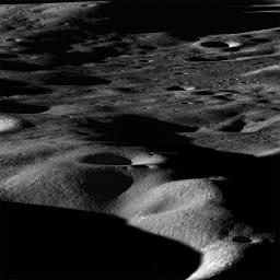
Most mountains on the Earth are formed as plates collide and the crust buckles. Not so for the Moon, where mountains are formed as a result of impacts. Images taken looking across the landscape rather than straight down really bring out topography and help us visualize the lunar landscape. However such images can only be taken as the spacecraft rolls to the side, in this case about 70°, so the opportunities are limited. Foreground is about 15 km wide, view is northeast across the north rim of Cabeus crater.
Cabeus crater is relatively old, 100 km in diameter, and contains significant areas of permanent shadow. Such regions are of great interest because they may harbor significant deposits of ices (water, methane, etc).
Background Info:
NASA's Goddard Space Flight Center built and manages the mission for the Exploration Systems Mission Directorate at NASA Headquarters in Washington. The Lunar Reconnaissance Orbiter Camera was designed to acquire data for landing site certification and to conduct polar illumination studies and global mapping. Operated by Arizona State University, the LROC facility is part of the School of Earth and Space Exploration (SESE). LROC consists of a pair of narrow-angle cameras (NAC) and a single wide-angle camera (WAC). The mission is expected to return over 70 terabytes of image data.
Cataloging Keywords:
| Name | Value | Additional Values |
|---|---|---|
| Target | Moon | |
| System | Earth | |
| Target Type | Satellite | |
| Mission | Lunar Reconnaissance Orbiter (LRO) | |
| Instrument Host | Lunar Reconnaissance Orbiter | |
| Host Type | Orbiter | |
| Instrument | Lunar Reconnaissance Orbiter Camera (NAC) | |
| Detector | Narrow Angle Camera (NAC), Wide Angle Camera (WAC) | |
| Extra Keywords | Crater, Grayscale, Impact, Methane, Mountain, Shadow, Water | |
| Acquisition Date | ||
| Release Date | 2009-11-17 | |
| Date in Caption | ||
| Image Credit | NASA/GSFC/Arizona State University | |
| Source | photojournal.jpl.nasa.gov/catalog/PIA12927 | |
| Identifier | PIA12927 | |
