|
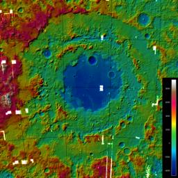
A Digital Terrain Model of the Orientale Basin
- Click the image above for a larger view
- Full-Res JPEG (1000 x 1000) (208.8 kB)
- Full-Res TIFF (1000 x 1000) (3.0 MB)
Caption:
A Digital Terrain Model (DTM) of the large Orientale Basin (1100 km diameter), located on the western hemisphere of the Moon, produced from stereo images obtained by LROC's Wide-Angle Camera. The image shows the hill-shaded, color-coded DTM with heights varying from approx. -4,700 meters to 9,400 meters. The small white boxes are areas without WAC coverage.
Background Info:
NASA's Goddard Space Flight Center built and manages the mission for the Exploration Systems Mission Directorate at NASA Headquarters in Washington. The Lunar Reconnaissance Orbiter Camera was designed to acquire data for landing site certification and to conduct polar illumination studies and global mapping. Operated by Arizona State University, the LROC facility is part of the School of Earth and Space Exploration (SESE). LROC consists of a pair of narrow-angle cameras (NAC) and a single wide-angle camera (WAC). The mission is expected to return over 70 terabytes of image data.
Cataloging Keywords:
| Name | Value | Additional Values |
|---|---|---|
| Target | Moon | |
| System | Earth | |
| Target Type | Satellite | |
| Mission | Lunar Reconnaissance Orbiter (LRO) | |
| Instrument Host | Lunar Reconnaissance Orbiter | |
| Host Type | Orbiter | |
| Instrument | Lunar Reconnaissance Orbiter Camera (WAC) | |
| Detector | Narrow Angle Camera (NAC), Wide Angle Camera (WAC) | |
| Extra Keywords | Color | |
| Acquisition Date | ||
| Release Date | 2010-01-20 | |
| Date in Caption | ||
| Image Credit | NASA/GSFC/Arizona State University | |
| Source | photojournal.jpl.nasa.gov/catalog/PIA12943 | |
| Identifier | PIA12943 | |
