|
Icy Layers and Climate Fluctuations near the Martian North Pole
- Click the image above for a larger view
- Full-Res JPEG (800 x 600) (110.2 kB)
- Full-Res TIFF (800 x 600) (1.4 MB)
Caption:
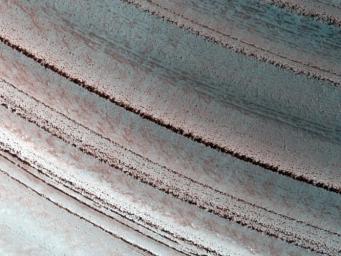
The Martian north polar layered deposits are an ice sheet much like the Greenland ice sheet on the Earth. Just as with the ice sheet in Greenland this Martian ice sheet contains many layers that record variations in the Martian climate. Sometimes icy layers can be ablated away during warm climates. Later the ice sheet can be buried by new ice layers and grow in size again. It's likely that many of these cycles have occurred over the ice sheet's history.
Fluctuations in the thickness of the ice sheet are most pronounced at the edges of the sheet, where this HiRISE image was taken. The ice sheet ends here in a gentle scarp that slopes about eight degrees downhill from bottom to top in this image. The layering within the ice is exposed on this sloping surface. The thickness of the ice here is about 1 kilometer (about 3300 feet). Scientists are analyzing these layers to see what information they might hold regarding previous Martian climates.
This image covers a swath of ground about 1 kilometer (about two-thirds of a mile) wide. It is a portion of HiRISE observation ESP_016973_2595, which is centered at 79.30 degrees north latitude, 351.46 degrees east longitude. The season on Mars is northern-hemisphere spring. Other image products from this observation are available at http://hirise.lpl.arizona.edu/ESP_016973_2595 .
Background Info:
The High Resolution Imaging Science Experiment (HiRISE) camera on NASA's Mars Reconnaissance Orbiter recorded this image of north polar layered deposits on March 11, 2010. The target for this observation was a suggestion submitted by Greg Clements through the camera team's HiWish public-suggestion program. For more information about how to submit target suggestions, see http://uahirise.org/hiwish/ .
Color images from HiRISE combine information from detectors with three different color filters: red, infrared, and blue-green. Thus they include information from part of the spectrum human eyes cannot see and are not true color as the eye would see. The resulting false color helps to show differences among surface materials.
The University of Arizona, Tucson, operates the HiRISE camera, which was built by Ball Aerospace & Technologies Corp., Boulder, Colo. NASA's Jet Propulsion Laboratory, a division of the California Institute of Technology, Pasadena, manages the Mars Reconnaissance Orbiter for the NASA Science Mission Directorate, Washington. Lockheed Martin Space Systems, Denver, built the spacecraft.
Cataloging Keywords:
| Name | Value | Additional Values |
|---|---|---|
| Target | Mars | |
| System | ||
| Target Type | Planet | |
| Mission | Mars Reconnaissance Orbiter (MRO) | |
| Instrument Host | Mars Reconnaissance Orbiter | |
| Host Type | Orbiter | |
| Instrument | High Resolution Imaging Science Experiment (HiRISE) | |
| Detector | ||
| Extra Keywords | Color, Infrared | |
| Acquisition Date | ||
| Release Date | 2010-03-31 | |
| Date in Caption | ||
| Image Credit | NASA/JPL-Caltech/University of Arizona | |
| Source | photojournal.jpl.nasa.gov/catalog/PIA12997 | |
| Identifier | PIA12997 | |
