skip to navigation

|
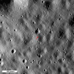
Highest Point on the Moon
- Click the image above for a larger view
- Full-Res JPEG (1000 x 1000) (149.0 kB)
- Full-Res TIFF (1000 x 1000) (3.0 MB)
Caption:
Arrow shows highest point on the Moon, 10,786 meters (35,387 feet) above the mean radius. North is up, Sun elevation is 16° from the horizon, image 500 meters (1640 feet) wide, from M133865651L,R mosaic.
Background Info:
NASA's Goddard Space Flight Center built and manages the mission for the Exploration Systems Mission Directorate at NASA Headquarters in Washington. The Lunar Reconnaissance Orbiter Camera was designed to acquire data for landing site certification and to conduct polar illumination studies and global mapping. Operated by Arizona State University, LROC consists of a pair of narrow-angle cameras (NAC) and a single wide-angle camera (WAC). The mission is expected to return over 70 terabytes of image data.
Cataloging Keywords:
| Name | Value | Additional Values |
|---|---|---|
| Target | Moon | |
| System | Earth | |
| Target Type | Satellite | |
| Mission | Lunar Reconnaissance Orbiter (LRO) | |
| Instrument Host | Lunar Reconnaissance Orbiter | |
| Host Type | Orbiter | |
| Instrument | Lunar Reconnaissance Orbiter Camera (NAC) | |
| Detector | Narrow Angle Camera (NAC), Wide Angle Camera (WAC) | |
| Extra Keywords | Color | |
| Acquisition Date | ||
| Release Date | 2010-10-26 | |
| Date in Caption | ||
| Image Credit | NASA/GSFC/Arizona State University | |
| Source | photojournal.jpl.nasa.gov/catalog/PIA13642 | |
| Identifier | PIA13642 | |
