|
Geologic Setting of Opportunity Traverse and Meridiani Planum
- Click the image above for a larger view
- Full-Res JPEG (2736 x 2250) (486.1 kB)
- Full-Res TIFF (2736 x 2250) (18.5 MB)
Caption:
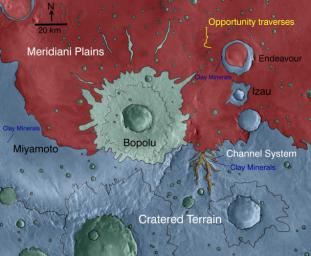
This map indicates geological units in the region of Mars around a smaller area where NASA's Mars Exploration Rover Opportunity has driven from early 2004 through late 2010.
The blue-coded unit encompassing most of the southern half of the mapped region is ancient cratered terrain. In the northern region, it is overlain by younger sediments of the Meridiani Plains, punctuated by the even younger Bopulu impact. At Endeavour Crater, in the upper right near the gold line of Opportunity's traverse, ancient cratered terrain is exposed around the crater rim. Locations where orbital observations have detected clay minerals are indicated at the western edge of Endeavour and at two locations in the southern portion of the map.
The scale bar is 20 kilometers (12.4 miles). The mineral mapping was done by Sandra Wiseman and Ray Arvidson of Washington Universty in St. Louis based on observations by the Compact Reconnaissance Imaging Spectrometer for Mars (CRISM) on NASA's Mars Reconnaissance Orbiter.
Cataloging Keywords:
| Name | Value | Additional Values |
|---|---|---|
| Target | Mars | |
| System | ||
| Target Type | Planet | |
| Mission | Mars Reconnaissance Orbiter (MRO) | Mars Exploration Rover (MER) |
| Instrument Host | Mars Reconnaissance Orbiter | Opportunity (MER-B) |
| Host Type | Orbiter | Rover |
| Instrument | Compact Reconnaissance Imaging Spectrometer for Mars (CRISM) | |
| Detector | ||
| Extra Keywords | Color, Crater, Impact, Map | |
| Acquisition Date | ||
| Release Date | 2010-12-16 | |
| Date in Caption | ||
| Image Credit | NASA/JPL-Caltech/JHUAPL/WUSTL | |
| Source | photojournal.jpl.nasa.gov/catalog/PIA13704 | |
| Identifier | PIA13704 | |
