Farside Northern Highlands
Caption:
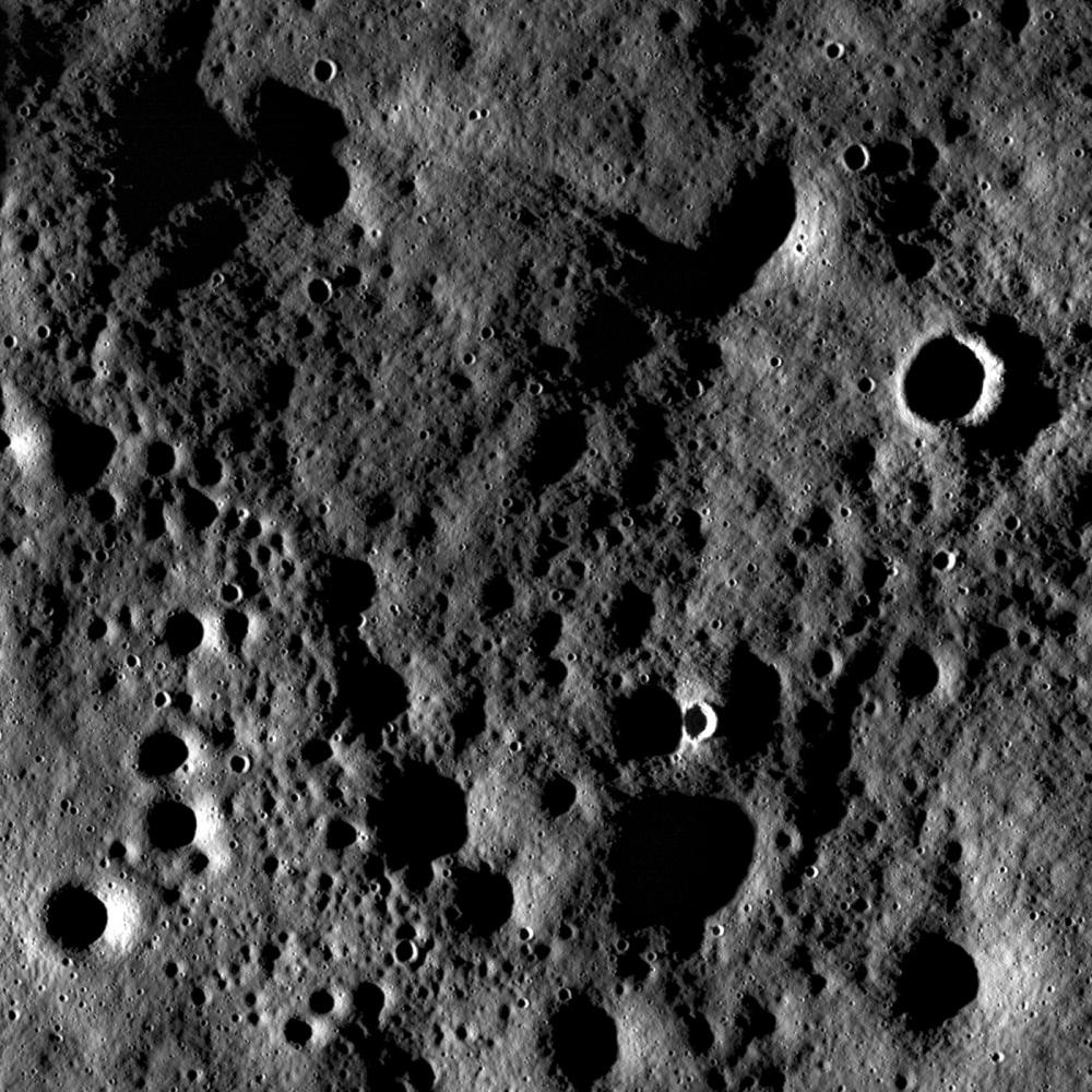
Rugged highland terrain on the farside of the Moon, south of Cantor crater. Image width is ~3.4 kilometers.
Close-up view on the lunar farside south of Cantor crater (38.2°N, 118.6°E) taken at sunset (incidence angle 87°). Although the pronounced shadows hide the interiors of craters, the high incidence angle exaggerates the surrounding terrain so that subtle surface features are enhanced. In these lighting conditions, the Moon looks pulverized, softened, and pock-marked with craters of variable sizes and relative ages. Some craters are very bright and have well-defined rims while others are barely noticeable as shallow depressions.
The large number of craters influence the texture of the surface as the impact process removes material from the site of impact and transports it as ejecta onto the surrounding surface. The redistribution of ejecta material churns up the regolith (a process called impact gardening), smoothing the surface and filling in older craters. While there are many small craters (<100 m in diameter) visible in this image, there are also much larger craters (hundreds to thousands of meters in diameter, such as the crater rim visible near the bottom of the full NAC image) in the vicinity of Cantor that are responsible for a significant redistribution of material. The surface in this NAC frame suggests that both the craters visible in this frame and those surrounding Cantor are responsible for the much of the surface texture we observe.
|
|
Click on image for larger version
|
|
|
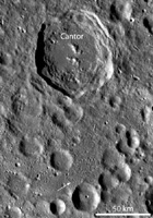
LROC WAC monochrome mosaic of Cantor crater and surrounding terrain. Cantor crater, ~81 kilometers diameter, is slightly elongated in the north-south direction and has a polygonal-shaped rim. The arrow notes the location of the opening LROC NAC image
|
|
Background Info:
NASA's Goddard Space Flight Center built and manages the mission for the Exploration Systems Mission Directorate at NASA Headquarters in Washington. The Lunar Reconnaissance Orbiter Camera was designed to acquire data for landing site certification and to conduct polar illumination studies and global mapping. Operated by Arizona State University, LROC consists of a pair of narrow-angle cameras (NAC) and a single wide-angle camera (WAC). The mission is expected to return over 70 terabytes of image data.
Cataloging Keywords:
| Name |
Value |
Additional Values |
| Target |
Moon |
|
| System |
Earth |
|
| Target Type |
Satellite |
|
| Mission |
Lunar Reconnaissance Orbiter (LRO) |
|
| Instrument Host |
Lunar Reconnaissance Orbiter |
|
| Host Type |
Orbiter |
|
| Instrument |
Lunar Reconnaissance Orbiter Camera (NAC) |
Lunar Reconnaissance Orbiter Camera (WAC) |
| Detector |
|
Narrow Angle Camera (NAC), Wide Angle Camera (WAC) |
| Extra Keywords |
Crater, Grayscale, Impact, Shadow |
| Acquisition Date |
|
| Release Date |
2011-02-15 |
| Date in Caption |
|
|
| Image Credit |
NASA/GSFC/Arizona State University |
| Source |
photojournal.jpl.nasa.gov/catalog/PIA14008 |
| Identifier |
PIA14008 |
