|
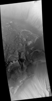
Light-Toned Layering in a Labyrinthus Noctis Pit
- Click the image above for a larger view
- Full-Res JPEG (2880 x 1800) (1.0 MB)
- Full-Res TIFF (2880 x 1800) (15.6 MB)
Caption:

Map Projected Browse Image
Click on the image for larger version
Understanding both the spatial and temporal distribution of hydrated (water-bearing) minerals on Mars is essential for deciphering the aqueous history of the planet. Over 300 meters of layered beds are exposed in this trough of Noctis Labyrinthus, at the western edge of Valles Marineris.
The beds are mixtures of light- and dark-toned materials, and include units that contain hydrated minerals, like sulfates and clays. Mapping these minerals and their stratigraphic relationships indicates numerous hydrologic and/or depositional events in localized environments spread over time.
The diversity of materials within the trough implies active hydrologic processes and/or changing chemical conditions, perhaps due to influxes of groundwater from nearby Tharsis volcanism.
This is a stereo pair with PSP_003910_1685 .
Background Info:
The University of Arizona, Tucson, operates HiRISE, which was built by Ball Aerospace & Technologies Corp., Boulder, Colo. NASA's Jet Propulsion Laboratory, a division of Caltech in Pasadena, California, manages the Mars Reconnaissance Orbiter Project for NASA's Science Mission Directorate, Washington.
Cataloging Keywords:
| Name | Value | Additional Values |
|---|---|---|
| Target | Mars | |
| System | ||
| Target Type | Planet | |
| Mission | Mars Reconnaissance Orbiter (MRO) | Mariner |
| Instrument Host | Mars Reconnaissance Orbiter | |
| Host Type | Orbiter | Flyby Spacecraft |
| Instrument | High Resolution Imaging Science Experiment (HiRISE) | |
| Detector | ||
| Extra Keywords | Color, Map, Volcano, Water | |
| Acquisition Date | ||
| Release Date | 2017-01-03 | |
| Date in Caption | ||
| Image Credit | NASA/JPL-Caltech/Univ. of Arizona | |
| Source | photojournal.jpl.nasa.gov/catalog/PIA14455 | |
| Identifier | PIA14455 | |
