skip to navigation

|
Nailing Down Curiosity’s Landing Site
- Click the image above for a larger view
- Full-Res JPEG (9000 x 6750) (6.0 MB)
- Full-Res TIFF (9000 x 6750) (182.3 MB)
Caption:
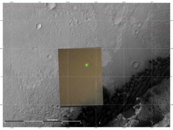
This image shows the location (green) where scientists estimate NASA's Curiosity rover landed on Mars within Gale Crater, based on images from the Mars Descent Imager (MARDI). The landing estimates derived from navigation and landing data agree to within 660 feet (200 meters) of this MARDI estimate.
The red line shows the northern edge of the targeted landing region, a probability distribution defined by an ellipse.
The gray scale image is a mosaic from the HiRISE camera on NASA's Mars Reconnaissance Orbiter. The color image is from MARDI.
Cataloging Keywords:
| Name | Value | Additional Values |
|---|---|---|
| Target | Mars | |
| System | ||
| Target Type | Planet | |
| Mission | Mars Science Laboratory (MSL) | Mars Reconnaissance Orbiter (MRO) |
| Instrument Host | Curiosity Rover | Mars Reconnaissance Orbiter |
| Host Type | Rover | Orbiter |
| Instrument | High Resolution Imaging Science Experiment (HiRISE) | Mars Descent Imager (MARDI) |
| Detector | ||
| Extra Keywords | Color, Crater | |
| Acquisition Date | ||
| Release Date | 2012-08-07 | |
| Date in Caption | ||
| Image Credit | NASA/JPL-Caltech/MSSS | |
| Source | photojournal.jpl.nasa.gov/catalog/PIA15996 | |
| Identifier | PIA15996 | |
