|
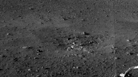
Rocket Thrusters Expose Bedrock
- Click the image above for a larger view
- Full-Res JPEG (1280 x 720) (111.5 kB)
- Full-Res TIFF (1280 x 720) (922.8 kB)
Caption:
This is a close-up view of the zones where the soil at Curiosity's landing site was blown away by the thrusters on the rover's descent stage. The excavation of the soil reveals probable bedrock outcrop. This is important because it shows the shallow depth of the soil in this area. The area surrounding the zones of excavation shows abundant small rocks that may form a pavement-like layer above harder bedrock.
This full-resolution image was taken by the rover's Navigation camera.
Background Info:
JPL manages the Mars Science Laboratory/Curiosity for NASA's Science Mission Directorate in Washington. The rover was designed, developed and assembled at JPL, a division of the California Institute of Technology in Pasadena.
For more about NASA's Curiosity mission, visit: http://www.jpl.nasa.gov/msl , http://www.nasa.gov/mars , and http://marsprogram.jpl.nasa.gov/msl .
Cataloging Keywords:
| Name | Value | Additional Values |
|---|---|---|
| Target | Mars | |
| System | ||
| Target Type | Planet | |
| Mission | Mars Science Laboratory (MSL) | |
| Instrument Host | Curiosity Rover | |
| Host Type | Rover | |
| Instrument | ||
| Detector | ||
| Extra Keywords | Grayscale | |
| Acquisition Date | ||
| Release Date | 2012-08-08 | |
| Date in Caption | ||
| Image Credit | NASA/JPL-Caltech | |
| Source | photojournal.jpl.nasa.gov/catalog/PIA16025 | |
| Identifier | PIA16025 | |
