|
Landing Accuracy on Mars: A Historical Perspective
- Click the image above for a larger view
- Full-Res JPEG (860 x 647) (90.7 kB)
- Full-Res TIFF (860 x 647) (1.7 MB)
Caption:
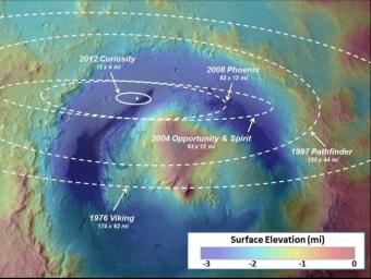
This image illustrates how spacecraft landings on Mars have become more and more precise over the years. Since NASA's first Mars landing of Viking in 1976, the targeted landing regions, or ellipses, have shrunk. Improvements in interplanetary navigation tightened the ellipses between the 1997 and 2008 landings of NASA's Pathfinder and Phoenix.
NASA's Curiosity used those improvements, in addition to hypersonic guided entry similar to that used by astronauts returning to Earth during NASA's Apollo program, to further reduce the ellipse size and land just north of the slopes of Mount Sharp. The area of Curiosity's landing ellipse was just seven percent the size of the previous best landing ellipse for Phoenix. This guided entry technique also allowed a much heavier rover to land on Mars.
The background picture is from the European Space Agency's Mars Express overlaid with topographical data from NASA's Mars Global Surveyor.
Cataloging Keywords:
| Name | Value | Additional Values |
|---|---|---|
| Target | Mars | |
| System | ||
| Target Type | Planet | |
| Mission | Mars Science Laboratory (MSL) | Mars Express, Mars Global Surveyor (MGS), Phoenix, Viking |
| Instrument Host | Curiosity Rover | Mars Global Surveyor, Phoenix Lander |
| Host Type | Rover | Lander, Orbiter |
| Instrument | ||
| Detector | ||
| Extra Keywords | Color | |
| Acquisition Date | ||
| Release Date | 2012-08-10 | |
| Date in Caption | ||
| Image Credit | NASA/JPL-Caltech/ESA | |
| Source | photojournal.jpl.nasa.gov/catalog/PIA16039 | |
| Identifier | PIA16039 | |
