|
Curiosity’s Roadside Discoveries
- Click the image above for a larger view
- Full-Res JPEG (932 x 720) (132.4 kB)
- Full-Res TIFF (932 x 720) (2.0 MB)
Caption:
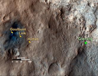
This map shows the path on Mars of NASA's Curiosity rover toward Glenelg, an area where three terrains of scientific interest converge. Arrows mark geological features encountered so far that led to the discovery of what appears to be an ancient Martian streambed. The first site, dubbed Goulburn, is an area where the thrusters from the rover's descent stage blasted away a layer of loose material, exposing bedrock underneath. Goulburn gave scientists a hint that water might have transported the pebbly sandstone material making up the outcrop. The second feature, a naturally exposed rock outcrop named Link, stood out to the science team for its embedded, rounded gravel pieces. Such rounded shapes are strong evidence of water transport. The final feature, another naturally exposed rock outcrop named Hottah, offered the most compelling evidence yet of an ancient stream, as it contains abundant rounded pebbles. The grain sizes are also an important part of the evidence for water: the rounded pebbles, which are up to 1.6 inches (4 centimeters) in size, are too large to have been transported by wind.
The image used for the map is from an observation of the landing site by the High Resolution Imaging Science Experiment (HiRISE) instrument on NASA's Mars Reconnaissance Orbiter.
Background Info:
JPL manages the Mars Science Laboratory/Curiosity for NASA's Science Mission Directorate in Washington. The rover was designed, developed and assembled at JPL, a division of the California Institute of Technology in Pasadena.
For more about NASA's Curiosity mission, visit: http://www.jpl.nasa.gov/msl , http://www.nasa.gov/mars , and http://marsprogram.jpl.nasa.gov/msl .
Cataloging Keywords:
| Name | Value | Additional Values |
|---|---|---|
| Target | Mars | |
| System | ||
| Target Type | Planet | |
| Mission | Mars Reconnaissance Orbiter (MRO) | Mars Science Laboratory (MSL) |
| Instrument Host | Mars Reconnaissance Orbiter | Curiosity Rover |
| Host Type | Orbiter | Rover |
| Instrument | High Resolution Imaging Science Experiment (HiRISE) | |
| Detector | ||
| Extra Keywords | Color, Map, Water | |
| Acquisition Date | ||
| Release Date | 2012-09-27 | |
| Date in Caption | ||
| Image Credit | NASA/JPL-Caltech/Univ. of Arizona | |
| Source | photojournal.jpl.nasa.gov/catalog/PIA16157 | |
| Identifier | PIA16157 | |
