|
Curiosity’s Location During First Scooping
- Click the image above for a larger view
- Full-Res JPEG (7703 x 2198) (1.9 MB)
- Full-Res TIFF (7703 x 2198) (16.9 MB)
Caption:
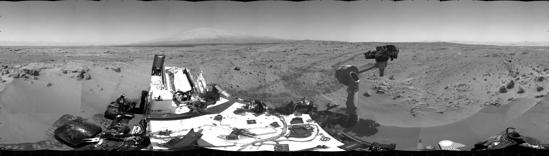
This 360-degree scene shows the surroundings of the location where NASA's Mars rover Curiosity arrived on the 59th Martian day, or sol, of the rover's mission on Mars (Oct. 5, 2012). It is a mosaic of images taken by Curiosity's Navigation Camera (Navcam) on sols 59 and 60.
Smooth surfaces of the windblown sand and dust of the "Rocknest" area, in the foreground, are what signaled from a distance that this might be an appropriate place to spend about three weeks collecting and using the mission's first few scoopfuls of soil. The rover scooped up its first sample on Sol 61 (Oct. 7, 2012).
South is at the center of this panorama, north at both ends. Mount Sharp is on the horizon in the southeast. The "Glenelg" area planned as the next destination lies to the east. Tracks that Curiosity's wheels made while driving toward Rocknest recede toward the west. For scale, Curiosity leaves parallel tracks about 9 feet (2.7 meters) apart.
The scene is presented here as a cylindrical projection.
Background Info:
JPL manages the Mars Science Laboratory/Curiosity for NASA's Science Mission Directorate in Washington. The rover was designed, developed and assembled at JPL, a division of the California Institute of Technology in Pasadena.
For more about NASA's Curiosity mission, visit: http://www.jpl.nasa.gov/msl , http://www.nasa.gov/mars , and http://marsprogram.jpl.nasa.gov/msl .
Cataloging Keywords:
| Name | Value | Additional Values |
|---|---|---|
| Target | Mars | |
| System | ||
| Target Type | Planet | |
| Mission | Mars Science Laboratory (MSL) | |
| Instrument Host | Curiosity Rover | |
| Host Type | Rover | |
| Instrument | Navigation Camera (Navcam) | |
| Detector | ||
| Extra Keywords | Dust, Grayscale | |
| Acquisition Date | ||
| Release Date | 2012-10-12 | |
| Date in Caption | 2012-10-05 | 2012-10-07 |
| Image Credit | NASA/JPL-Caltech | |
| Source | photojournal.jpl.nasa.gov/catalog/PIA16227 | |
| Identifier | PIA16227 | |