
|
Curiosity Traverse Map, Sol 123
- Click the image above for a larger view
- Full-Res JPEG (3300 x 2550) (1.7 MB)
- Full-Res TIFF (3300 x 2550) (25.3 MB)
Caption:
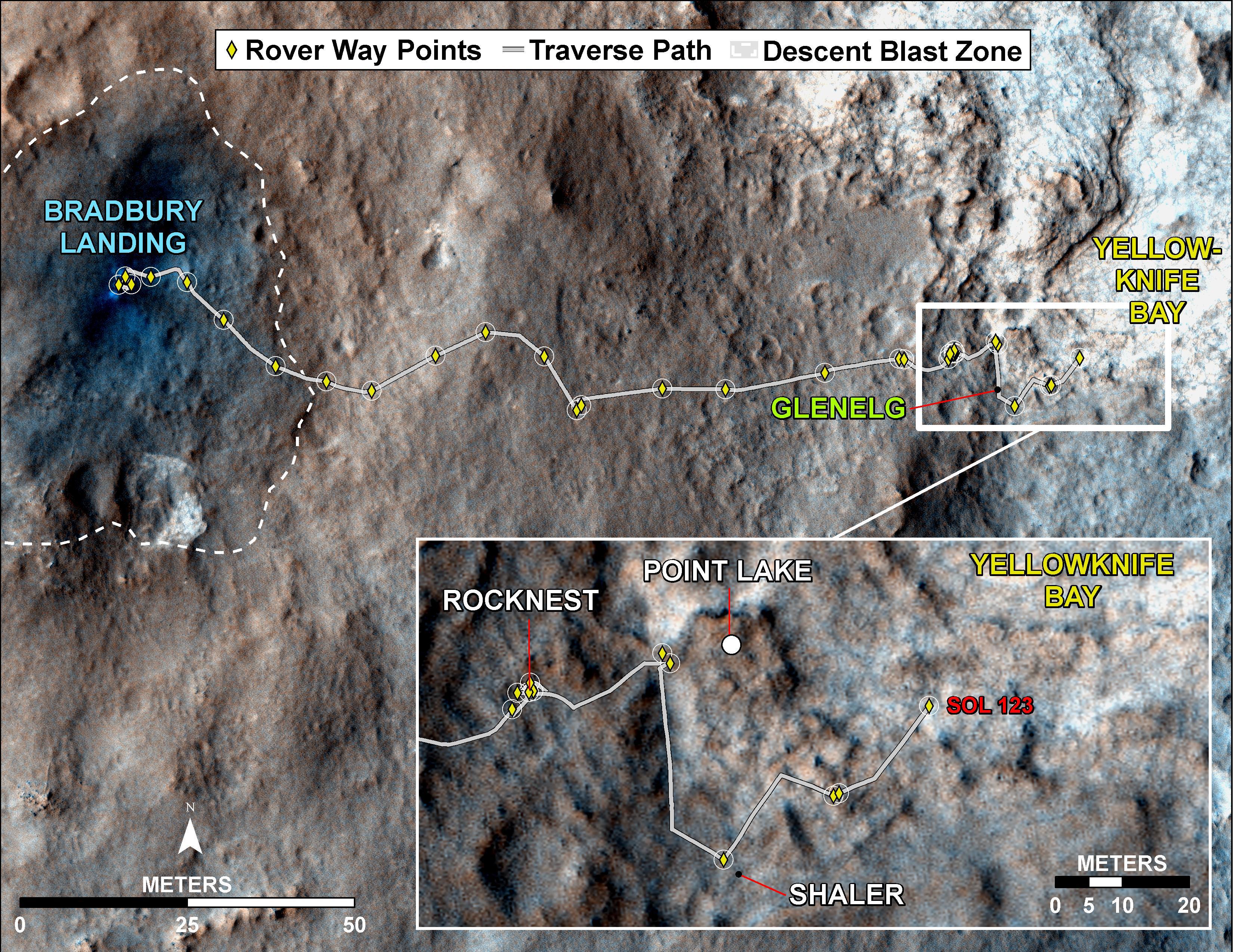
This map traces where NASA's Mars rover Curiosity drove between landing at a site subsequently named "Bradbury Landing," and the position reached during the mission's 123rd Martian day, or sol, (Dec. 10, 2012). The inset shows the most recent legs of the traverse in greater detail.
With the Sol 123 drive of 63 feet (19 meters), the rover approached a step down into an area called "Yellowknife Bay," which is a potential location for selecting the first target rock for Curiosity's hammering drill. The drive brought the mission's total driving odometry to 0.37 mile (598 meters). Three sols earlier, Curiosity stopped near a layered outcrop informally named "Shaler," and acquired the image seen at PIA16550 .
The mapped area is within Gale Crater and north of the mountain called Mount Sharp in the middle of the crater. After the first use of the drill, the rover's main science destination will be on the lower reaches of Mount Sharp. For broader-context images of the area, see PIA16064 and PIA16058 .
The base image from the map is from the High Resolution Imaging Science Experiment Camera (HiRISE) in NASA's Mars Reconnaissance Orbiter.
Background Info:
NASA's Jet Propulsion Laboratory manages the Mars Science Laboratory/Curiosity for NASA's Science Mission Directorate in Washington. The mission's Curiosity rover was designed, developed and assembled at JPL, a division of the California Institute of Technology in Pasadena.
For more about NASA's Curiosity mission, visit: http://www.jpl.nasa.gov/msl , http://www.nasa.gov/mars , and http://mars.jpl.nasa.gov/msl .
Cataloging Keywords:
| Name | Value | Additional Values |
|---|---|---|
| Target | Mars | |
| System | ||
| Target Type | Planet | |
| Mission | Mars Reconnaissance Orbiter (MRO) | Mars Science Laboratory (MSL) |
| Instrument Host | Mars Reconnaissance Orbiter | Curiosity Rover |
| Host Type | Orbiter | Rover |
| Instrument | High Resolution Imaging Science Experiment (HiRISE) | |
| Detector | ||
| Extra Keywords | Color, Crater, Map, Mountain | |
| Acquisition Date | ||
| Release Date | 2012-12-11 | |
| Date in Caption | 2012-12-10 | |
| Image Credit | NASA/JPL-Caltech/Univ. of Arizona | |
| Source | photojournal.jpl.nasa.gov/catalog/PIA16459 | |
| Identifier | PIA16459 | |