|
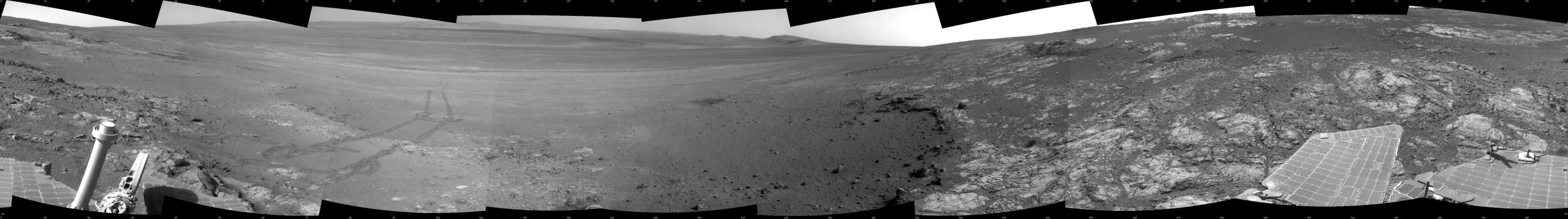
Opportunity’s Surroundings on Sol 3071, on ‘Whitewater Lake’ Outcrop
- Click the image above for a larger view
- Full-Res JPEG (7688 x 1073) (1.1 MB)
- Full-Res TIFF (7688 x 1073) (8.3 MB)
Caption:
This full-circle panorama shows the terrain around the NASA Mars Exploration Rover Opportunity during the 3,071st Martian day, or sol, of the rover's work on Mars (Sept. 13, 2012). It was assembled from images taken by the rover's navigation camera. South is at the center. North is on both ends.
Opportunity had driven about 34 feet (10.3 meters) the preceding sol to reach this location, which is on part of a relatively flat, light-toned outcrop called "Whitewater Lake." A darker, adjacent outcrop, called "Kirkwood," lies just east of the rover's location and cuts a band through the middle of this view.
The basin of Endeavour Crater is in the left half of the image. Opportunity has been working on the western rim of Endeavour since mid-2011.
The panorama is presented as a cylindrical projection.
Cataloging Keywords:
| Name | Value | Additional Values |
|---|---|---|
| Target | Mars | |
| System | ||
| Target Type | Planet | |
| Mission | Mars Exploration Rover (MER) | |
| Instrument Host | Opportunity (MER-B) | |
| Host Type | Rover | |
| Instrument | Navigation Camera (Navcam) | |
| Detector | ||
| Extra Keywords | Crater, Grayscale, Water | |
| Acquisition Date | ||
| Release Date | 2012-12-19 | |
| Date in Caption | ||
| Image Credit | NASA/JPL-Caltech | |
| Source | photojournal.jpl.nasa.gov/catalog/PIA16556 | |
| Identifier | PIA16556 | |