
|
GRAIL Identifies Moon Dikes
- Click the image above for a larger view
- Full-Res JPEG (3051 x 1614) (525.4 kB)
- Full-Res TIFF (3051 x 1614) (14.8 MB)
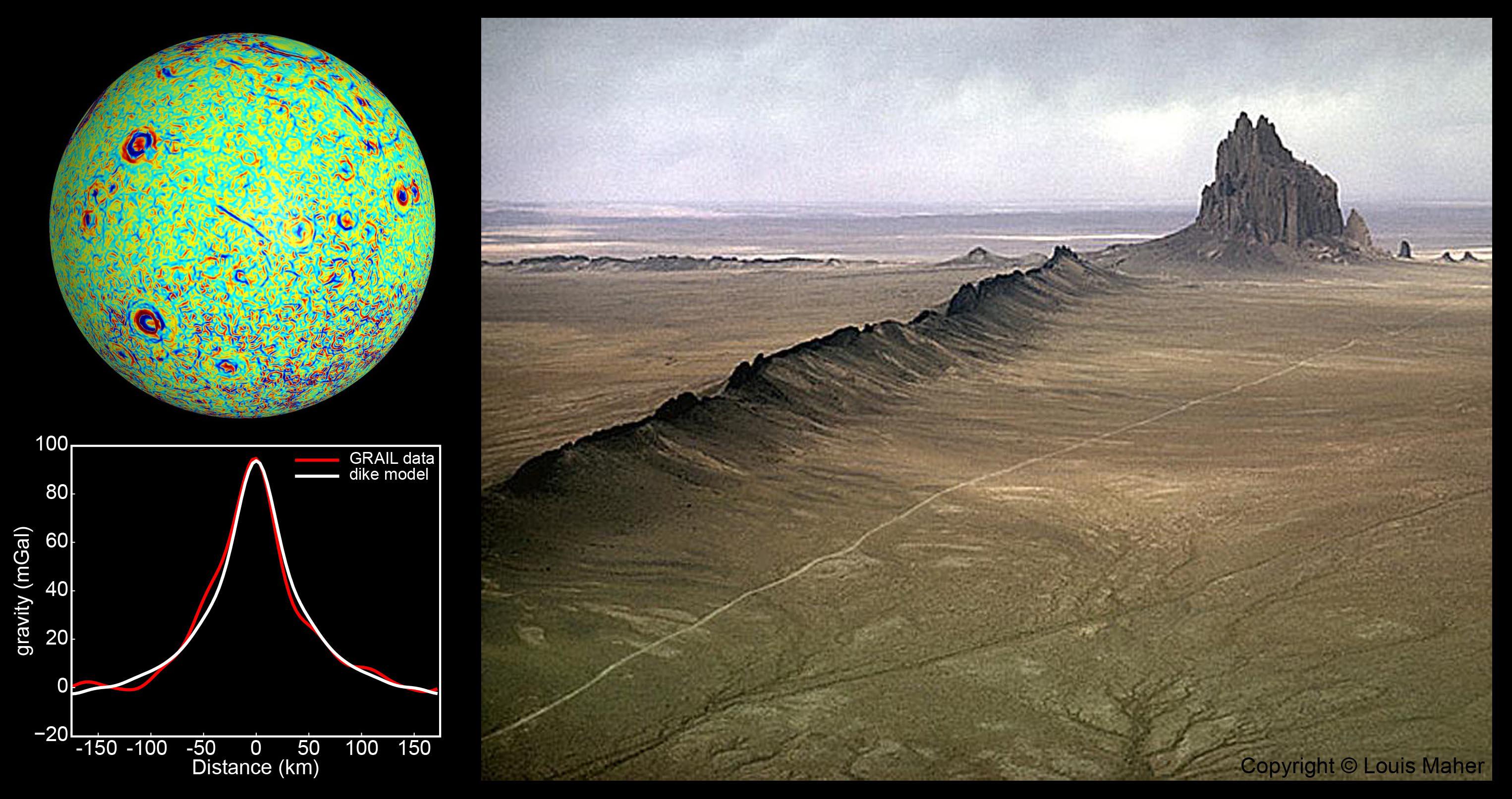
Caption:
A profile across one of the linear gravity anomalies found by NASA's GRAIL mission shows that it has higher gravity than the surroundings (the anomaly is the red line in graph at bottom left; its location is shown as a blue line in the center of the GRAIL gravity gradient map at top left). Models show that this gravity pattern indicates the presence of giant dikes beneath the surface of the moon (white line in graph at bottom left). A dike is a solidified magma filled crack that forms beneath the surface. Dikes on Earth are sometimes exposed by erosion so that they are visible on the surface, as seen at Ship Rock, New Mexico, pictured here at right. The lunar dikes identified by GRAIL are 50 times longer and 1,000 times wider than the dike seen here.
Background Info:
NASA's Jet Propulsion Laboratory in Pasadena, Calif., manages the GRAIL mission for NASA's Science Mission Directorate in Washington. The Massachusetts Institute of Technology, Cambridge, is home to the mission's principal investigator, Maria Zuber. GRAIL is part of the Discovery Program managed at NASA's Marshall Space Flight Center in Huntsville, Ala. Lockheed Martin Space Systems in Denver built the spacecraft. The California Institute of Technology in Pasadena manages JPL for NASA.
For more information about GRAIL, please visit http://grail.nasa.gov .
Cataloging Keywords:
| Name | Value | Additional Values |
|---|---|---|
| Target | Moon | |
| System | Earth | |
| Target Type | Satellite | |
| Mission | GRAIL | |
| Instrument Host | GRAIL | |
| Host Type | ||
| Instrument | ||
| Detector | ||
| Extra Keywords | Color, Map | |
| Acquisition Date | ||
| Release Date | 2012-12-05 | |
| Date in Caption | ||
| Image Credit | Left: NASA/JPL-Caltech/CSM, Right: Photo Copyright (c) Louis Maher | |
| Source | photojournal.jpl.nasa.gov/catalog/PIA16583 | |
| Identifier | PIA16583 | |