
|
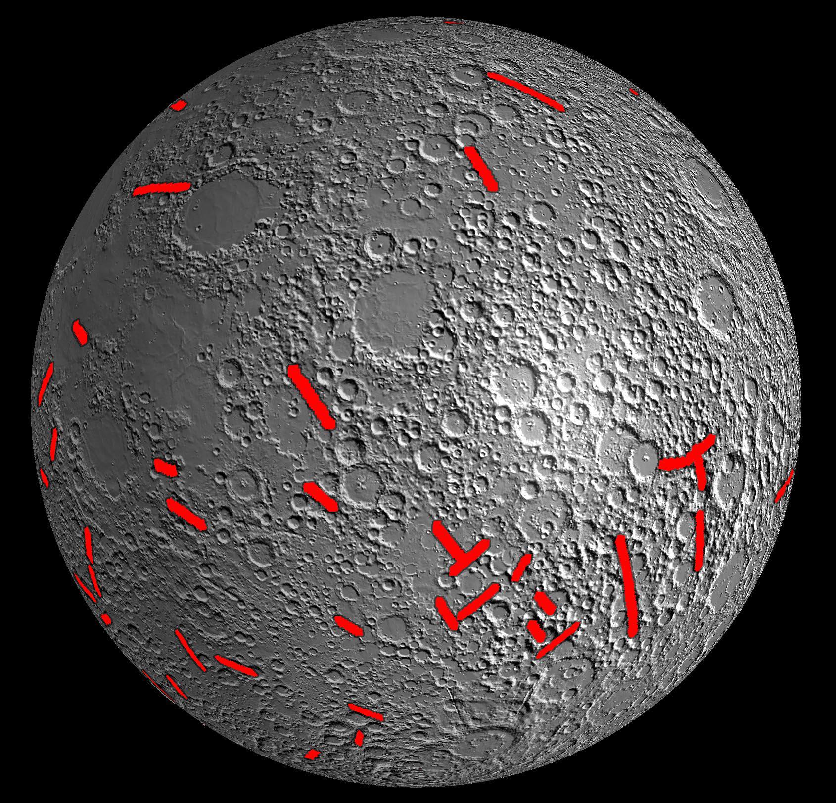
Moon Dike Map
- Click the image above for a larger view
- Full-Res JPEG (1690 x 1623) (590.6 kB)
- Full-Res TIFF (1690 x 1623) (8.2 MB)
Caption:
This map of one side of the moon shows the location of some of the giant dikes identified by NASA's GRAIL mission. These dikes are solidified magma filled cracks with lengths up to 300 miles (480 kilometers) and widths of up to 24 miles (40 kilometers). The formation of these dikes tells us that the moon expanded during the first billion years of its history, with its radius increasing by as much as 3 miles (5 kilometers). This early expansion of the moon was previously predicted by theoretical models, and is now confirmed by GRAIL gravity data.
The base map consists of topographic shaded data from NASA's Lunar Reconnaissance Orbiter's Lunar Orbiter Laser Altimeter.
Background Info:
NASA's Jet Propulsion Laboratory in Pasadena, Calif., manages the GRAIL mission for NASA's Science Mission Directorate in Washington. The Massachusetts Institute of Technology, Cambridge, is home to the mission's principal investigator, Maria Zuber. GRAIL is part of the Discovery Program managed at NASA's Marshall Space Flight Center in Huntsville, Ala. Lockheed Martin Space Systems in Denver built the spacecraft. The California Institute of Technology in Pasadena manages JPL for NASA.
For more information about GRAIL, please visit http://grail.nasa.gov .
Cataloging Keywords:
| Name | Value | Additional Values |
|---|---|---|
| Target | Moon | |
| System | Earth | |
| Target Type | Satellite | |
| Mission | GRAIL | Lunar Reconnaissance Orbiter (LRO) |
| Instrument Host | GRAIL | |
| Host Type | ||
| Instrument | Lunar Orbiter Laser Altimeter | |
| Detector | ||
| Extra Keywords | Color, Map | |
| Acquisition Date | ||
| Release Date | 2012-12-05 | |
| Date in Caption | ||
| Image Credit | NASA/JPL-Caltech/CSM | |
| Source | photojournal.jpl.nasa.gov/catalog/PIA16584 | |
| Identifier | PIA16584 | |