|
Visualization of Buried Marte Vallis Channels
- Click the image above for a larger view
- Full-Res JPEG (1000 x 692) (74.9 kB)
- Full-Res TIFF (1000 x 692) (2.1 MB)
Caption:
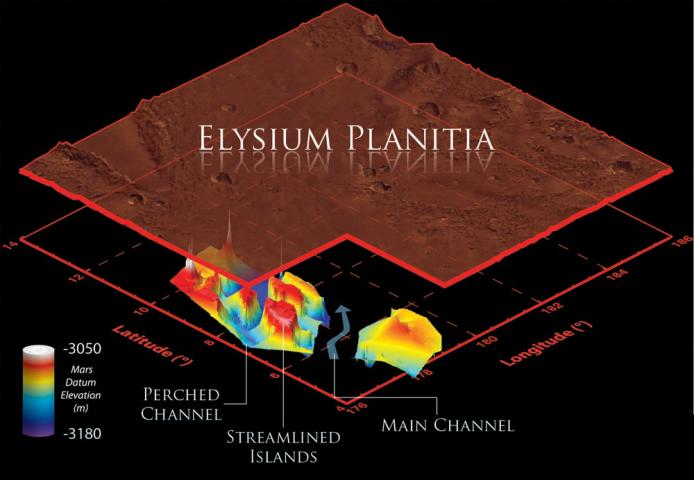
This illustration schematically shows where the Shallow Radar instrument on NASA's Mars Reconnaissance Orbiter detected flood channels that had been buried by lava flows in the Elysium Planitia region of Mars.
Marte Vallis consists of multiple perched channels formed around streamlined islands. These channels feed a deeper and wider main channel.
In this illustration, the surface has been elevated, and scaled by a factor of one to 100 for clarity. The color scale represents the elevation of the buried channels relative to a Martian datum, or reference elevation. The reason the values are negative is because the elevation of the surface of Mars in this region is also a negative -- below average global elevation.
Background Info:
SHARAD was provided by the Italian Space Agency. Its operations are led by Sapienza University of Rome, and its data are analyzed by a joint U.S.-Italian science team. NASA's Jet Propulsion Laboratory, a division of the California Institute of Technology in Pasadena, manages the Mars Reconnaissance Orbiter for the NASA Science Mission Directorate, Washington. Lockheed Martin Space Systems, Denver, built the spacecraft.
Cataloging Keywords:
| Name | Value | Additional Values |
|---|---|---|
| Target | Mars | |
| System | ||
| Target Type | Planet | |
| Mission | Mars Reconnaissance Orbiter (MRO) | |
| Instrument Host | Mars Reconnaissance Orbiter | |
| Host Type | Orbiter | |
| Instrument | Shallow Subsurface Radar (SHARAD) | |
| Detector | ||
| Extra Keywords | Color, Radar | |
| Acquisition Date | ||
| Release Date | 2013-03-07 | |
| Date in Caption | ||
| Image Credit | NASA/JPL-Caltech/Sapienza University of Rome/Smithsonian Institution/USGS | |
| Source | photojournal.jpl.nasa.gov/catalog/PIA16767 | |
| Identifier | PIA16767 | |