|
Hydration Map, Based on Mastcam Spectra, for ‘Knorr’ Rock Target
- Click the image above for a larger view
- Full-Res JPEG (1344 x 1200) (288.0 kB)
- Full-Res TIFF (1344 x 1200) (4.8 MB)
Caption:
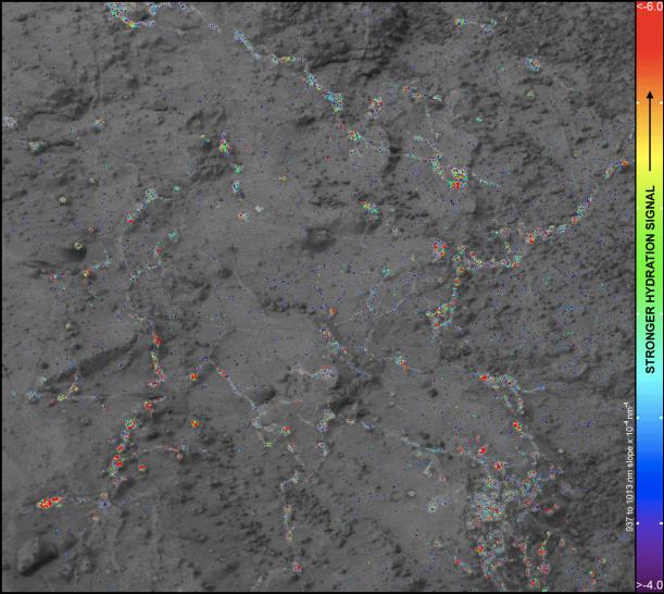
On this image of the rock target "Knorr," color coding maps the amount of mineral hydration indicated by a ratio of near-infrared reflectance intensities measured by the Mast Camera (Mastcam) on NASA's Mars rover Curiosity. The color scale on the left shows the assignment of colors for relative strength of the calculated signal for hydration. The map shows that the stronger signals for hydration are associated with pale veins and light-toned nodules in the rock. This image and the data for assessing hydration come from a Mastcam observation of Knorr during the 133rd Martian day, or sol, of Curiosity's work on Mars (Dec. 20, 2012). The width of the area shown in the image is about 10 inches (25 centimeters).
Background Info:
Curiosity's Mastcam was built and is operated by Malin Space Science Systems, San Diego.
NASA's Jet Propulsion Laboratory, Pasadena, Calif., manages the Mars Science Laboratory Project and the mission's Curiosity rover for NASA's Science Mission Directorate in Washington. The rover was designed and assembled at JPL, a division of the California Institute of Technology in Pasadena.
More information about Curiosity is online at http://www.nasa.gov/msl and http://mars.jpl.nasa.gov/msl/ .
Cataloging Keywords:
| Name | Value | Additional Values |
|---|---|---|
| Target | Mars | |
| System | ||
| Target Type | Planet | |
| Mission | Mars Science Laboratory (MSL) | |
| Instrument Host | Curiosity Rover | |
| Host Type | Rover | |
| Instrument | Mast Camera (MastCam) | |
| Detector | ||
| Extra Keywords | Color, Infrared, Map | |
| Acquisition Date | ||
| Release Date | 2013-03-18 | |
| Date in Caption | 2012-12-20 | |
| Image Credit | NASA/JPL-Caltech/MSSS/ASU | |
| Source | photojournal.jpl.nasa.gov/catalog/PIA16794 | |
| Identifier | PIA16794 | |