|
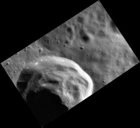
Crater Down
- Click the image above for a larger view
- Full-Res JPEG (1924 x 1763) (211.0 kB)
- Full-Res TIFF (1924 x 1763) (3.4 MB)
Caption:
The crater in this stunning image has prominent slump deposits that were created as the crater and ejecta collapsed back in on itself immediately after crater formation. If you look closely, you can also see that the rim appears to host small patches of hollows . One clue to understanding hollow formation is that they appear to form preferentially on sunward facing slopes (because this crater is at a high northern latitude, its northern wall gets the most exposure to the Sun). This extra heating may enhance the loss of volatiles PIA14853 from the surface.
This image was acquired as a high-resolution targeted observation. Targeted observations are images of a small area on Mercury's surface at resolutions much higher than the 200-meter/pixel morphology base map. It is not possible to cover all of Mercury's surface at this high resolution, but typically several areas of high scientific interest are imaged in this mode each week.
Date acquired:
October 12, 2012
Image Mission Elapsed Time (MET):
258544256
Image ID:
2752092
Instrument:
Narrow Angle Camera (NAC) of the Mercury Dual Imaging System (MDIS)
Center Latitude:
59.38°
Center Longitude:
307.2° E
Resolution:
16 meters/pixel
Scale:
This crater is 17 km (11 mi.) in diameter
Incidence Angle:
71.8°
Emission Angle:
50.2°
Phase Angle:
122.1°
Background Info:
The MESSENGER spacecraft is the first ever to orbit the planet Mercury, and the spacecraft's seven scientific instruments and radio science investigation are unraveling the history and evolution of the Solar System's innermost planet. MESSENGER acquired over 150,000 images and extensive other data sets. MESSENGER is capable of continuing orbital operations until early 2015.
For information regarding the use of images, see the MESSENGER image use policy .
Cataloging Keywords:
| Name | Value | Additional Values |
|---|---|---|
| Target | Mercury | |
| System | ||
| Target Type | Planet | |
| Mission | MESSENGER | |
| Instrument Host | MESSENGER | |
| Host Type | Orbiter | |
| Instrument | Mercury Dual Imaging System (MDIS) | |
| Detector | Narrow Angle Camera (NAC) | |
| Extra Keywords | Crater, Grayscale, Map, Radio | |
| Acquisition Date | ||
| Release Date | 2013-04-04 | |
| Date in Caption | 2012-10-12 | |
| Image Credit | NASA/Johns Hopkins University Applied Physics Laboratory/Carnegie Institution of Washington | |
| Source | photojournal.jpl.nasa.gov/catalog/PIA16948 | |
| Identifier | PIA16948 | |
