|
Defacing a Basin
- Click the image above for a larger view
- Full-Res JPEG (1394 x 1377) (151.4 kB)
- Full-Res TIFF (1394 x 1377) (1.9 MB)
Caption:
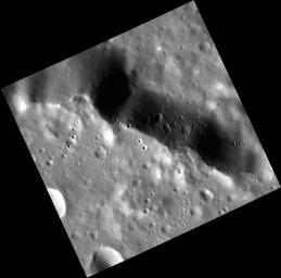
The rim of an unnamed peak-ring basin cuts across today's featured image. The basin is relatively degraded, but its rim still stands as a cliff over 1 km (0.6 miles) high. The face of this cliff, where downslope is toward the top of the image, is covered by a chain of secondary craters, whose formation on this steep slope led to somewhat asymmetrical crater shapes. It's hard to say which crater these secondaries originated from - the region is crossed by rays from Bronte , over 1700 km to the west, and Hokusai , over 2000 km to the east.
This image was acquired as a high-resolution targeted observation. Targeted observations are images of a small area on Mercury's surface at resolutions much higher than the 200-meter/pixel morphology base map. It is not possible to cover all of Mercury's surface at this high resolution, but typically several areas of high scientific interest are imaged in this mode each week.
Date acquired:
April 12, 2013
Image Mission Elapsed Time (MET):
8108630
Image ID:
3870271
Instrument:
Narrow Angle Camera (NAC) of the Mercury Dual Imaging System (MDIS)
Center Latitude:
41.15°
Center Longitude:
289.3° E
Resolution:
22 meters/pixel
Scale:
This scene is approximately 25 km (16 miles) across
Incidence Angle:
64.0°
Emission Angle:
15.0°
Phase Angle:
79.0°
Background Info:
The MESSENGER spacecraft is the first ever to orbit the planet Mercury, and the spacecraft's seven scientific instruments and radio science investigation are unraveling the history and evolution of the Solar System's innermost planet. MESSENGER acquired over 150,000 images and extensive other data sets. MESSENGER is capable of continuing orbital operations until early 2015.
For information regarding the use of images, see the MESSENGER image use policy .
Cataloging Keywords:
| Name | Value | Additional Values |
|---|---|---|
| Target | Mercury | |
| System | ||
| Target Type | Planet | |
| Mission | MESSENGER | |
| Instrument Host | MESSENGER | |
| Host Type | Orbiter | |
| Instrument | Mercury Dual Imaging System (MDIS) | |
| Detector | Narrow Angle Camera (NAC) | |
| Extra Keywords | Crater, Grayscale, Map, Radio | |
| Acquisition Date | ||
| Release Date | 2013-05-01 | |
| Date in Caption | 2013-04-12 | |
| Image Credit | NASA/Johns Hopkins University Applied Physics Laboratory/Carnegie Institution of Washington | |
| Source | photojournal.jpl.nasa.gov/catalog/PIA17024 | |
| Identifier | PIA17024 | |
