|
Landing Area Narrowed for 2016 InSight Mission to Mars
- Click the image above for a larger view
- Full-Res JPEG (4000 x 2298) (2.3 MB)
- Full-Res TIFF (4000 x 2298) (27.6 MB)
Caption:

Click on the image for larger view of unannotated version
Right-click here to download full resolution image
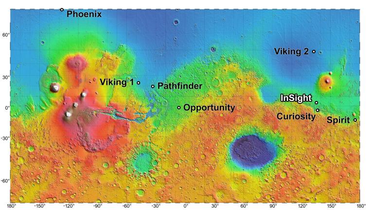
The process of selecting a site for NASA's next landing on Mars, planned for September 2016, has narrowed to four semifinalist sites located close together in the Elysium Planitia region of Mars. The mission known by the acronym InSight will study the Red Planet's interior, rather than surface features, to advance understanding of the processes that formed and shaped the rocky planets of the inner solar system, including Earth. The location of the cluster of semifinalist landing sites for InSight is indicated on this near-global topographic map of Mars, which also indicates landing sites of current and past NASA missions to the surface of Mars. The mission's full name is Interior Exploration Using Seismic Investigations, Geodesy and Heat Transport.
The location of Elysium Planitia close to the Martian equator meets an engineering requirement for the stationary InSight lander to receive adequate solar irradiation year-round on its photovoltaic array. The location also meets an engineering constraint for low elevation, optimizing the amount of atmosphere the spacecraft can use for deceleration during its descent to the surface. The number of candidate landing sites for InSight was trimmed from 22 down to four in August 2013. This down-selection facilitates focusing the efforts to further evaluate the four sites. Cameras on NASA's Mars Reconnaissance Orbiter will be used to gather more information about them before the final selection.
The topographic map uses data from the Mars Orbiter Laser Altimeter on NASA's Mars Global Surveyor spacecraft. The color coding on this map indicates elevation relative to a reference datum, since Mars has no "sea level." The lowest elevations are presented as dark blue; the highest as white. The difference between green and orange in the color coding is about 2.5 miles (4 kilometers) vertically.
Background Info:
InSight will deploy a heat-flow probe designed to hammer itself 3 to 5 yards (or meters) deep and monitor heat coming from the planet's interior. The mission will also use a seismometer and radio science. The French space agency Centre National d'Etudes Spatiales, or CNES, and the German Aerospace Center, or DLR, are contributing instruments to the mission. Lockheed Martin Space Systems, Denver, is building the spacecraft.
InSight is part of NASA's Discovery Program of competitively selected solar system exploration missions with highly focused scientific goals. NASA's Marshall Space Flight Center in Huntsville, Ala., manages the Discovery Program for the agency's Science Mission Directorate in Washington. NASA's Jet Propulsion Laboratory, a division of the California Institute of Technology, Pasadena, manages InSight for the NASA Science Mission Directorate. For more information about InSight, visit: http://insight.jpl.nasa.gov . Additional information on the Discovery Program is available at: http://discovery.nasa.gov .
Photojournal Note : After thorough examination, NASA managers have decided to suspend the planned March 2016 launch of the Interior Exploration using Seismic Investigations Geodesy and Heat Transport (InSight) mission. The decision follows unsuccessful attempts to repair a leak in a section of the prime instrument in the science payload.
Cataloging Keywords:
| Name | Value | Additional Values |
|---|---|---|
| Target | Mars | |
| System | ||
| Target Type | Planet | |
| Mission | InSight | Mars Global Surveyor (MGS), Mars Reconnaissance Orbiter (MRO) |
| Instrument Host | InSight Lander | Mars Global Surveyor, Mars Reconnaissance Orbiter |
| Host Type | Lander | Orbiter |
| Instrument | Mars Orbiter Laser Altimeter (MOLA) | |
| Detector | ||
| Extra Keywords | Atmosphere, Color, Map, Radio | |
| Acquisition Date | ||
| Release Date | 2013-09-04 | |
| Date in Caption | ||
| Image Credit | NASA/JPL-Caltech | |
| Source | photojournal.jpl.nasa.gov/catalog/PIA17357 | |
| Identifier | PIA17357 | |