|
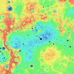
Digital Elevation Model of Mercury’s Northern Hemisphere
- Click the image above for a larger view
- Full-Res JPEG (1536 x 1536) (289.2 kB)
- Full-Res TIFF (1536 x 1536) (2.4 MB)
Caption:
The above image is from a digital elevation model (DEM) created by using orbital MLA data . The colors illustrate Mercury's topography, which spans roughly from -5 km (deep blue) to 5 km (red). The specific color bar is given on the ACT-REACT QuickMap description of this DEM layer. Also in QuickMap, this DEM can be used to generate 3D views of the surface.
The DEM can be downloaded on MESSENGER's Global Mosaics of Mercury webpage in a variety of formats and resolutions. The DEM was created by using MLA orbital data through that released by the PDS on March 8, 2013. Due to MESSENGER's highly elliptical orbit , MLA can only range to the surface in the northern hemisphere. Consequently, the DEM products derived from MLA data only cover the northern hemisphere of Mercury. Additionally, the accuracy of each DEM product is higher closer to the north pole, and near the equator, the data are highly interpolated.
Instrument:
Mercury Laser Altimeter (MLA)
Center Latitude:
90° N
Map Projection:
Polar stereographic projection, extending southward to 55° N, with 0° longitude at the bottom
Resolution:
2 km/pixel
Scale:
The distance across the center of this polar map projection is approximately 2,980 kilometers (1850 miles)
Download:
Global Mosaics of Mercury Webpage
Background Info:
The MESSENGER spacecraft is the first ever to orbit the planet Mercury, and the spacecraft's seven scientific instruments and radio science investigation are unraveling the history and evolution of the Solar System's innermost planet. MESSENGER acquired over 150,000 images and extensive other data sets. MESSENGER is capable of continuing orbital operations until early 2015.
For information regarding the use of images, see the MESSENGER image use policy .
Cataloging Keywords:
| Name | Value | Additional Values |
|---|---|---|
| Target | Mercury | |
| System | ||
| Target Type | Planet | |
| Mission | MESSENGER | |
| Instrument Host | MESSENGER | |
| Host Type | Orbiter | |
| Instrument | Mercury Laser Altimeter (MLA) | |
| Detector | ||
| Extra Keywords | Color, Map, Radio | |
| Acquisition Date | ||
| Release Date | 2013-07-17 | |
| Date in Caption | 2013-03-08 | |
| Image Credit | NASA/Johns Hopkins University Applied Physics Laboratory/Carnegie Institution of Washington | |
| Source | photojournal.jpl.nasa.gov/catalog/PIA17385 | |
| Identifier | PIA17385 | |
