|
Mawrth Vallis Geodiversity
- Click the image above for a larger view
- Full-Res JPEG (2880 x 1800) (815.4 kB)
- Full-Res TIFF (2880 x 1800) (15.6 MB)
Caption:
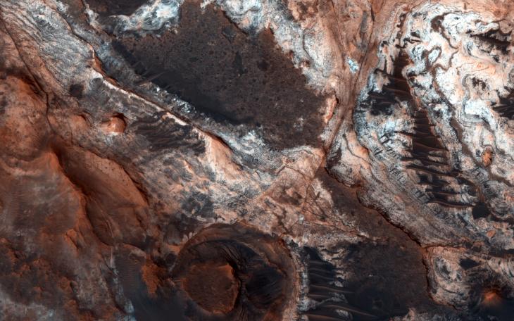
This image shows a small portion of Mawrth Vallis, one of the many outflow channels feeding north into the Chryse Basin. This ancient valley once hosted flowing water. The erosive power of the flowing water rapidly cut down into the underlying layers of rock to expose a host of diverse geologic landforms visible today.
A focus of geologic study (at this site on Mars as well as many locations on Earth) is deciphering the juxtaposition of various rock structures and landforms . The superposition of one landform or strata above another, fractures and faults that disrupt one layer but not another, and the depths of certain mineralogical signatures all tell a story of the geological and climatological history of the region.
Intensely fractured bedrock is visible at all scales (meters to kilometers), revealing that subsurface rock has undergone a complex history of stresses and deformation, such as stretching, compression, and twisting. Wider dark ridges are also visible, crossing long distances through the fractured bedrock and between the various exposed layers. These ridges may be what geologists call "dikes," near vertical fissures in the subsurface rock that became injected with magma, and which later cooled into the is now an exposed vein of dark volcanic rock.
These dikes may be related to areas of dark and rough (likely volcanic) cap rock that now covers and protects the light toned strata below. Erosion through and around this cap rock has exposed a myriad of light toned layers. These layers reveal a past ancient environment where geologic material (perhaps volcanic ash, fine sand, and dust) settled slowly from the air or at the bottom of a standing body of water. In addition, spectroscopic signatures of phyllosilicate minerals (clays) indicates a history of geochemical alteration of primary minerals which in some way involved liquid water.
These geologic structures and the processes that formed them mostly predate the already ancient flood waters that carved Mawrth Vallis. However, processes continue to change and evolve the landscape into the present day. Overlying the surface are scattered dark dunes and small sand sheets. These landforms tells us that wind continues to move and shift the dark volcanic sands across the surface. In addition, lighter-toned loose soil and coatings of the ever present reddish dust (very fine grained weathered rock particles that is continuously blown around the planet) blankets much of the surface. The presence of this soil tell us that, while slow, rock continues to weather both physically and chemically, and break down into the finer soil particles.
Background Info:
HiRISE is one of six instruments on NASA's Mars Reconnaissance Orbiter. The University of Arizona, Tucson, operates the orbiter's HiRISE camera, which was built by Ball Aerospace & Technologies Corp., Boulder, Colo. NASA's Jet Propulsion Laboratory, a division of the California Institute of Technology in Pasadena, manages the Mars Reconnaissance Orbiter Project for the NASA Science Mission Directorate, Washington.
Cataloging Keywords:
| Name | Value | Additional Values |
|---|---|---|
| Target | Mars | |
| System | ||
| Target Type | Planet | |
| Mission | Mars Reconnaissance Orbiter (MRO) | |
| Instrument Host | Mars Reconnaissance Orbiter | |
| Host Type | Orbiter | |
| Instrument | High Resolution Imaging Science Experiment (HiRISE) | |
| Detector | ||
| Extra Keywords | Color, Dune, Dust, Volcano, Water | |
| Acquisition Date | ||
| Release Date | 2013-07-10 | |
| Date in Caption | ||
| Image Credit | NASA/JPL-Caltech/Univ. of Arizona | |
| Source | photojournal.jpl.nasa.gov/catalog/PIA17723 | |
| Identifier | PIA17723 | |