|
And the Walls Came Tumbling Down
- Click the image above for a larger view
- Full-Res JPEG (1539 x 1470) (192.3 kB)
- Full-Res TIFF (1539 x 1470) (2.3 MB)
Caption:
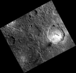
This image brings us back to the vicinity of Matisse, the subject of several recent Gallery images . The unnamed impact crater with the bright pyroclastic deposit on its southern floor also has two arcuate scallops on its northern wall. These were the sites of massive landslides that took place when the oversteepened crater wall collapsed. The ultimate cause of the collapse is the topography of the area where the crater formed: the northern part of the crater formed on the wall of Matisse.
This image was acquired as part of MDIS's high-resolution albedo base map. The best images for discerning variations in albedo, or brightness, on the surface are acquired when the Sun is overhead, so these images typically are taken at low incidence angles. The albedo base map covers Mercury's surface at an average resolution of 200 meters/pixel.
Date acquired:
April 05, 2012
Image Mission Elapsed Time (MET):
242124773
Image ID:
1609270
Instrument:
Narrow Angle Camera (NAC) of the Mercury Dual Imaging System (MDIS)
Center Latitude:
-22.85°
Center Longitude:
267.3° E
Resolution:
196 meters/pixel
Scale:
The crater with the bright floor is about 70 km (44 mi.) in diameter
Incidence Angle:
40.8°
Emission Angle:
30.0°
Phase Angle:
70.8°
Background Info:
The MESSENGER spacecraft is the first ever to orbit the planet Mercury, and the spacecraft's seven scientific instruments and radio science investigation are unraveling the history and evolution of the Solar System's innermost planet. MESSENGER acquired over 150,000 images and extensive other data sets. MESSENGER is capable of continuing orbital operations until early 2015.
For information regarding the use of images, see the MESSENGER image use policy .
Cataloging Keywords:
| Name | Value | Additional Values |
|---|---|---|
| Target | Mercury | |
| System | ||
| Target Type | Planet | |
| Mission | MESSENGER | |
| Instrument Host | MESSENGER | |
| Host Type | Orbiter | |
| Instrument | Mercury Dual Imaging System (MDIS) | |
| Detector | Narrow Angle Camera (NAC) | |
| Extra Keywords | Crater, Grayscale, Impact, Map, Radio, Rotation | |
| Acquisition Date | ||
| Release Date | 2013-12-02 | |
| Date in Caption | 2012-04-05 | |
| Image Credit | NASA/Johns Hopkins University Applied Physics Laboratory/Carnegie Institution of Washington | |
| Source | photojournal.jpl.nasa.gov/catalog/PIA17745 | |
| Identifier | PIA17745 | |
