|
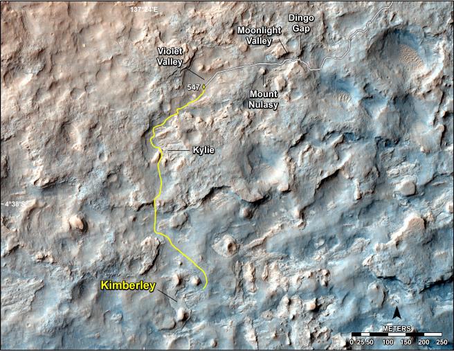
Map of Recent and Planned Driving by Curiosity as of Feb. 18, 2014
- Click the image above for a larger view
- Full-Res JPEG (3300 x 2550) (1.7 MB)
- Full-Res TIFF (3300 x 2550) (25.3 MB)
Caption:
This map shows the route driven and route planned for NASA's Curiosity Mars rover from before reaching "Dingo Gap" -- in upper right -- to the mission's next science waypoint, "Kimberley" (formerly referred to as "KMS-9") -- in lower left. The point labeled 547 on the route is where Curiosity finished a drive of 319 feet (100.3 meters) on the 547th Martian day, or sol, of the rover's mission on Mars (Feb. 18, 2014). The map's line to that point is the path actually traveled; the yellow line past that is a planned route.
Curiosity entered the area covered by this map in late 2013 and passed through Dingo Gap on Sol 535 (Feb. 9, 2014). To see the traverse through Sol 546 (Feb. 17, 2014) in larger context to include earlier parts of the mission, see http://mars.jpl.nasa.gov/msl/multimedia/images/?ImageID=6007 .
The base image for this map is a combination of images from the High Resolution Imaging Science Experiment (HiRISE) camera on NASA's Mars Reconnaissance Orbiter. North is up.
Background Info:
NASA's Jet Propulsion Laboratory, a division of the California Institute of Technology, Pasadena, manages the Mars Science Laboratory Project for NASA's Science Mission Directorate, Washington. JPL designed and built the project's Curiosity rover and Navcam.
More information about Curiosity is online at http://www.nasa.gov/msl and http://mars.jpl.nasa.gov/msl/ .
Cataloging Keywords:
| Name | Value | Additional Values |
|---|---|---|
| Target | Mars | |
| System | ||
| Target Type | Planet | |
| Mission | Mars Science Laboratory (MSL) | Mars Reconnaissance Orbiter (MRO) |
| Instrument Host | Curiosity Rover | Mars Reconnaissance Orbiter |
| Host Type | Rover | Orbiter |
| Instrument | ||
| Detector | ||
| Extra Keywords | Color, Map | |
| Acquisition Date | ||
| Release Date | 2014-02-19 | |
| Date in Caption | 2014-02-09 | 2014-02-17, 2014-02-18 |
| Image Credit | NASA/JPL-Caltech/Univ. of Arizona | |
| Source | photojournal.jpl.nasa.gov/catalog/PIA17946 | |
| Identifier | PIA17946 | |