skip to navigation

|
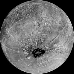
Source Region for Possible Europa Plumes
- Click the image above for a larger view
- Full-Res JPEG (2161 x 2161) (987.7 kB)
- Full-Res TIFF (2161 x 2161) (4.7 MB)
Caption:
This reprojection of the official USGS Europa basemap is centered at the estimated source region for potential plumes that might have been detected using the Hubble Space Telescope. The view is centered at -65 degrees latitude, 183 degrees longitude.
In addition to the plume source region, the image also shows the hemisphere of Europa that might be affected by plume deposits. This map is composed of images from NASA's Galileo and Voyager missions. The black region near the south pole results from gaps in imaging coverage.
Background Info:
For more information about Europa, visit: http://solarsystem.nasa.gov/europa/home.cfm .
JPL is a division of the California Institute of Technology in Pasadena.
Cataloging Keywords:
| Name | Value | Additional Values |
|---|---|---|
| Target | Europa | |
| System | Jupiter | |
| Target Type | Satellite | |
| Mission | Galileo | Hubble Space Telescope (HST), Voyager |
| Instrument Host | Galileo Orbiter, Hubble Space Telescope | |
| Host Type | Orbiter | Flyby Spacecraft, Space Telescope |
| Instrument | ||
| Detector | ||
| Extra Keywords | Grayscale, Map, Plume | |
| Acquisition Date | ||
| Release Date | 2014-02-26 | |
| Date in Caption | ||
| Image Credit | NASA/JPL-Caltech/SETI Institute | |
| Source | photojournal.jpl.nasa.gov/catalog/PIA18030 | |
| Identifier | PIA18030 | |
