|
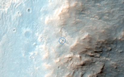
Opportunity Rover on Valentine’s Day 2014
- Click the image above for a larger view
- Full-Res JPEG (2880 x 1800) (565.0 kB)
- Full-Res TIFF (2880 x 1800) (15.6 MB)
Caption:

Map Projected Browse Image
Click on the image for larger version
This is the latest HiRISE image of Opportunity rover at Solander Point, where it spent a few weeks investigating Pinnacle rock (the "jelly donut") that was flipped over by the rover wheel.
We planned this image when this "new" rock was first seen; one hypothesis was that a recent impact deposited the rock. We see no obvious signs of a very recent crater in our image, but a careful comparison to prior images might reveal subtle changes (besides the rover position).
Changes in this region of Mars might be most likely from the action of wind (there are active sand dunes on the floor of Endeavour Crater), but new impacts could occur anywhere. The rover is located in the exact center of the color cutout .
Background Info:
HiRISE is one of six instruments on NASA's Mars Reconnaissance Orbiter. The University of Arizona, Tucson, operates the orbiter's HiRISE camera, which was built by Ball Aerospace & Technologies Corp., Boulder, Colo. NASA's Jet Propulsion Laboratory, a division of the California Institute of Technology in Pasadena, manages the Mars Reconnaissance Orbiter Project for the NASA Science Mission Directorate, Washington.
Cataloging Keywords:
| Name | Value | Additional Values |
|---|---|---|
| Target | Mars | |
| System | ||
| Target Type | Planet | |
| Mission | Mars Reconnaissance Orbiter (MRO) | Mars Exploration Rover (MER) |
| Instrument Host | Mars Reconnaissance Orbiter | Opportunity (MER-B) |
| Host Type | Orbiter | Rover |
| Instrument | High Resolution Imaging Science Experiment (HiRISE) | |
| Detector | ||
| Extra Keywords | Color, Crater, Dune, Impact, Map | |
| Acquisition Date | ||
| Release Date | 2014-04-09 | |
| Date in Caption | ||
| Image Credit | NASA/JPL-Caltech/Univ. of Arizona | |
| Source | photojournal.jpl.nasa.gov/catalog/PIA18122 | |
| Identifier | PIA18122 | |
