
|
Sandy Martian Valleys in Curiosity’s Near Future
- Click the image above for a larger view
- Full-Res JPEG (3300 x 2550) (1.2 MB)
- Full-Res TIFF (3300 x 2550) (25.3 MB)
Caption:
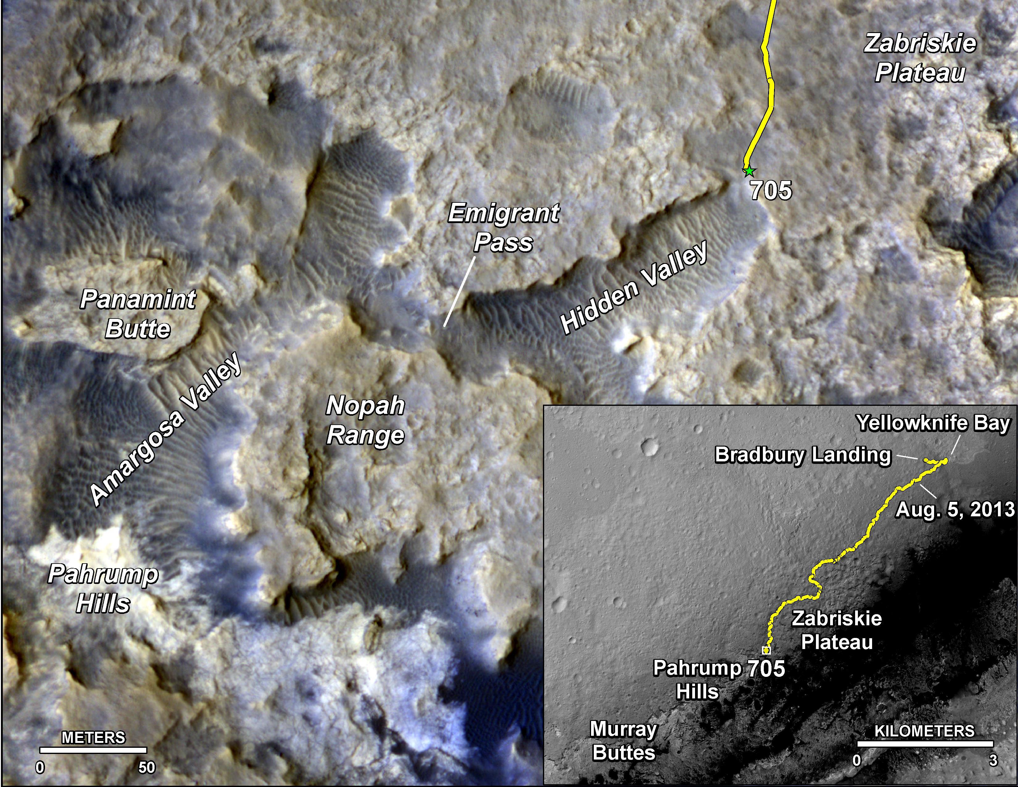
The main map here shows the assortment of landforms near the location of NASA's Curiosity Mars rover as the rover's second anniversary of landing on Mars nears. The gold traverse line entering from upper right ends at Curiosity's position as of the 705th Martian day, or sol, of the mission on Mars (July 31, 2014). The inset map shows the mission's entire traverse from the landing on Aug. 5, 2012, PDT (Aug. 6, UTC) to Sol 705, and the remaining distance to long-term science destinations near Murray Buttes, at the base of Mount Sharp. The label "Aug. 5, 2013" indicates where Curiosity was one year after landing.
Curiosity spent much of July 2014 crossing an upland area called "Zabriskie Plateau," where embedded, sharp rocks presented hazards for the rover's wheels. The traverse line enters the main map at the rover's location as of Sol 692 (July 17, 2014). A near-term science destination is the "Pahrump Hills" feature near the lower left corner. Scientists anticipate that outcrop rock there may provide a preview of a geological unit that is part of the base of Mount Sharp, rather than floor of Gale Crater. Between the Sol 705 location and Pahrump Hills, the rover's anticipated route dips into sandy-floored valleys.
Scale bars are 50 meters (164 feet) on the main map and 3 kilometers (1.9 miles) on the inset map. The base images for the map are from the High Resolution Imaging Science Experiment (HiRISE) camera on NASA's Mars Reconnaissance Orbiter. For broader-context views of the area that Curiosity is crossing within Gale Crater, see PIA16064 <?a > and PIA15687 .
Before the first anniversary of the landing, NASA's Mars Science Laboratory Project, which built and operates Curiosity, achieved its main science objective of determining whether Mars ever offered environmental conditions favorable for microbial life. Rock-powder samples drilled from two mudstone rocks at Yellowknife Bay and analyzed onboard yielded evidence for an ancient lakebed with mild water, the chemical elements needed for life and a mineral source of energy used by some Earth microbes.
Background Info:
NASA's Jet Propulsion Laboratory, a division of the California Institute of Technology, Pasadena, manages the Mars Science Laboratory Project and Mars Reconnaissance Orbiter Project for NASA's Science Mission Directorate, Washington.
Cataloging Keywords:
| Name | Value | Additional Values |
|---|---|---|
| Target | Mars | |
| System | ||
| Target Type | Planet | |
| Mission | Mars Reconnaissance Orbiter (MRO) | Mars Science Laboratory (MSL) |
| Instrument Host | Mars Reconnaissance Orbiter | Curiosity Rover |
| Host Type | Orbiter | Rover |
| Instrument | High Resolution Imaging Science Experiment (HiRISE) | |
| Detector | ||
| Extra Keywords | Color, Crater, Map, Water | |
| Acquisition Date | ||
| Release Date | 2014-08-01 | |
| Date in Caption | 2012-08-05 | 2013-08-05, 2014-07-17, 2014-07-31 |
| Image Credit | NASA/JPL-Caltech/Univ. of Arizona | |
| Source | photojournal.jpl.nasa.gov/catalog/PIA18408 | |
| Identifier | PIA18408 | |