|
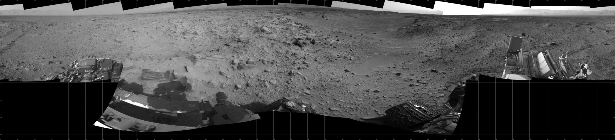
Curiosity’s 360-Degree View Before Entering ‘Hidden Valley’
- Click the image above for a larger view
- Full-Res JPEG (7696 x 1750) (1.5 MB)
- Full-Res TIFF (7696 x 1750) (13.5 MB)
Caption:
This panorama of the landscape surrounding NASA's Curiosity Mars rover on July 31, 2014, offers a view into sandy lower terrain called "Hidden Valley," which is on the planned route ahead. The full-circle vista combines several images taken by Curiosity's Navigation Camera in the afternoon of the mission's 705th Martian day, or sol, after completion of Sol 705's drive of about 16 feet (4.9 meters). South is at the center, north at both ends.
For the preceding few weeks, Curiosity had been crossing a plateau studded with embedded, sharp rocks. The planned route ahead from this Sol 705 location takes the rover southwestward through Hidden Valley, across sandier ground. The valley is about 150 feet (about 45 meters) wide. For a map showing this area, see PIA18408 .
For scale, the distance between Curiosity's parallel wheel tracks entering the scene near the left edge is about 9 feet (2.7 meters). The panorama is presented here as a cylindrical projection.
Background Info:
NASA's Jet Propulsion Laboratory, a division of the California Institute of Technology, Pasadena, manages the Mars Science Laboratory Project for NASA's Science Mission Directorate, Washington. JPL designed and built the project's Curiosity rover and the rover's Navcam.
Cataloging Keywords:
| Name | Value | Additional Values |
|---|---|---|
| Target | Mars | |
| System | ||
| Target Type | Planet | |
| Mission | Mars Science Laboratory (MSL) | |
| Instrument Host | Curiosity Rover | |
| Host Type | Rover | |
| Instrument | Panoramic Camera (Pancam) | |
| Detector | ||
| Extra Keywords | Grayscale, Map | |
| Acquisition Date | ||
| Release Date | 2014-08-01 | |
| Date in Caption | 2014-07-31 | |
| Image Credit | NASA/JPL-Caltech | |
| Source | photojournal.jpl.nasa.gov/catalog/PIA18409 | |
| Identifier | PIA18409 | |