|
At the Edge of a Polar Cap
- Click the image above for a larger view
- Full-Res JPEG (2880 x 1800) (796.4 kB)
- Full-Res TIFF (2880 x 1800) (15.6 MB)
Caption:

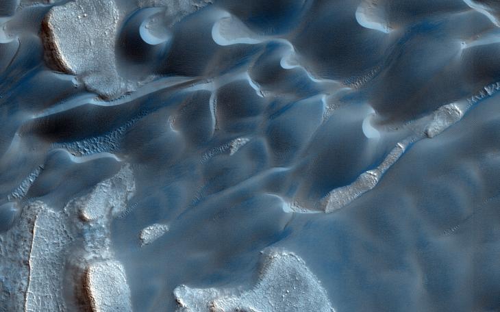
Map Projected Browse Image
Click on the image for larger version
Formative down-slope winds descending on Mars' North Polar ice cap likely play an important role in transporting sediment from the base of the ice cap into the dune fields that sit beyond the ice cap .
The deep chasm that formed on the polar cap edge is identified as an area of strong down-slope winds and has a clear connection to Mars' largest dune field, Olympia Undae. Repeat HiRISE images from this chasm that specifically targets the dunes, provides the basis to evaluate the sand fluxes which are associated with the dune and ripple movement in this area.
This is a stereo pair with ESP_036176_2640 .
Background Info:
HiRISE is one of six instruments on NASA's Mars Reconnaissance Orbiter. The University of Arizona, Tucson, operates HiRISE, which was built by Ball Aerospace & Technologies Corp., Boulder, Colorado. NASA's Jet Propulsion Laboratory, a division of the California Institute of Technology in Pasadena, manages the Mars Reconnaissance Orbiter Project for NASA's Science Mission Directorate, Washington.
Cataloging Keywords:
| Name | Value | Additional Values |
|---|---|---|
| Target | Mars | |
| System | ||
| Target Type | Planet | |
| Mission | Mars Reconnaissance Orbiter (MRO) | |
| Instrument Host | Mars Reconnaissance Orbiter | |
| Host Type | Orbiter | |
| Instrument | High Resolution Imaging Science Experiment (HiRISE) | |
| Detector | ||
| Extra Keywords | Color, Dune, Map | |
| Acquisition Date | ||
| Release Date | 2014-05-22 | |
| Date in Caption | ||
| Image Credit | NASA/JPL-Caltech/Univ. of Arizona | |
| Source | photojournal.jpl.nasa.gov/catalog/PIA18771 | |
| Identifier | PIA18771 | |