|
A Collection of Landforms in Eastern Elysium Planitia
- Click the image above for a larger view
- Full-Res JPEG (2880 x 1800) (595.3 kB)
- Full-Res TIFF (2880 x 1800) (15.6 MB)
Caption:

Map Projected Browse Image
Click on the image for larger version
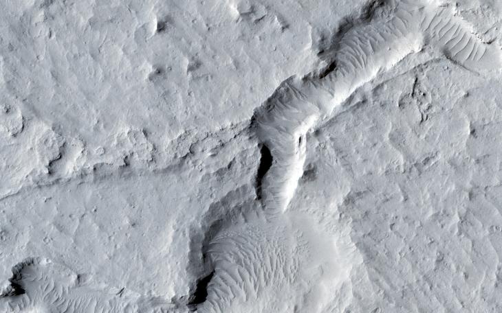
This image shows a great deal of geologic diversity in a rather small area.
In the northern section of the image, we see flat terrain that is probably an ancient lava field. This field runs up against a mesa, with slopes that show several dark streaks, possibly freshly disturbed material that is darker than the surrounding area and hasn't had time to fade. These dust avalanches are common in dust-covered regions on Mars.
Further south, we see a line of pits and also fretted terrain, before we come across a network of channels and depressions that dominate the southern portion of the observation.
Background Info:
HiRISE is one of six instruments on NASA's Mars Reconnaissance Orbiter. The University of Arizona, Tucson, operates HiRISE, which was built by Ball Aerospace & Technologies Corp., Boulder, Colorado. NASA's Jet Propulsion Laboratory, a division of the California Institute of Technology in Pasadena, manages the Mars Reconnaissance Orbiter Project for NASA's Science Mission Directorate, Washington.
Cataloging Keywords:
| Name | Value | Additional Values |
|---|---|---|
| Target | Mars | |
| System | ||
| Target Type | Planet | |
| Mission | Mars Reconnaissance Orbiter (MRO) | |
| Instrument Host | Mars Reconnaissance Orbiter | |
| Host Type | Orbiter | |
| Instrument | High Resolution Imaging Science Experiment (HiRISE) | |
| Detector | ||
| Extra Keywords | Color, Dust, Map | |
| Acquisition Date | ||
| Release Date | 2014-10-15 | |
| Date in Caption | ||
| Image Credit | NASA/JPL-Caltech/Univ. of Arizona | |
| Source | photojournal.jpl.nasa.gov/catalog/PIA18831 | |
| Identifier | PIA18831 | |