|
Sediment Accumulation in Dry and Wet Periods
- Click the image above for a larger view
- Full-Res JPEG (5271 x 1865) (1.2 MB)
- Full-Res TIFF (5271 x 1865) (29.5 MB)
Caption:
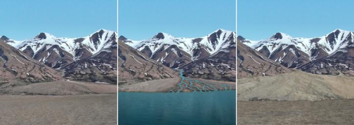
This series of images reconstructs the geology of the region around Mars' Mount Sharp, where NASA's Curiosity Mars rover landed and is now driving. The images, taken on Earth in Svalbard, Norway, have been altered for the illustration.
The mountain range serves as the rim of Gale Crater, the crater that surrounds Mount Sharp. In Mars' past, almost 4 billion years ago, water from snowmelt flowed down the mountain, creating an alluvial fan, delta and lake basin. The region oscillated between wet and dry periods, as illustrated here. A dry period is shown at left, during which rocks in the mountains weather away, creating sediment that is transported down the once-wet river system. The middle panel shows a wet period, where water is flowing. Sediments are transported, building up the fan, delta, and lake floor. In the subsequent dry period shown at right, the water is gone. The exposed fan and lake floor are now at higher elevations due to the transport of sediment during the previous wet period.
This infilling process by sediments, a phenomenon known to occur in topographic basins on Earth, provides a hypothesis for how the lower part of Gale Crater became filled up to a depth of hundreds of yards (meters) or even a kilometer (0.6 mile).
Background Info:
More information about Curiosity is online at http://www.nasa.gov/msl and http://mars.jpl.nasa.gov/msl/ .
Cataloging Keywords:
| Name | Value | Additional Values |
|---|---|---|
| Target | Earth | Mars |
| System | ||
| Target Type | Planet | |
| Mission | Mars Science Laboratory (MSL) | |
| Instrument Host | Curiosity Rover | |
| Host Type | Rover | |
| Instrument | ||
| Detector | ||
| Extra Keywords | Color, Crater, Mountain, Water | |
| Acquisition Date | ||
| Release Date | 2014-12-08 | |
| Date in Caption | ||
| Image Credit | NASA/JPL-Caltech | |
| Source | photojournal.jpl.nasa.gov/catalog/PIA19078 | |
| Identifier | PIA19078 | |
