|
Inverted Ridges in the Eridania Basin
- Click the image above for a larger view
- Full-Res JPEG (2880 x 1800) (923.3 kB)
- Full-Res TIFF (2880 x 1800) (15.6 MB)
Caption:
Map Projected Browse Image
Click on the image for larger version
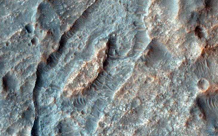
This closeup of a HiRISE image covers a region in the Eridania Basin that shows interesting inverted ridges ( white arrows ).
The ridges display a dendritic, or branched, pattern and may have once been connected to a larger channel ( black arrows ). One possible way these ridges formed is when smaller valleys filled in with sediments. These sediments became cemented and lithified which made them stronger than their surroundings.
Over time, erosion removed the surrounding terrain but the lithified sediments in the valleys are stronger so they have remained and now appear higher (or inverted) than their surroundings.
Background Info:
HiRISE is one of six instruments on NASA's Mars Reconnaissance Orbiter. The University of Arizona, Tucson, operates HiRISE, which was built by Ball Aerospace & Technologies Corp., Boulder, Colorado. NASA's Jet Propulsion Laboratory, a division of the California Institute of Technology in Pasadena, manages the Mars Reconnaissance Orbiter Project for NASA's Science Mission Directorate, Washington.
Cataloging Keywords:
| Name | Value | Additional Values |
|---|---|---|
| Target | Mars | |
| System | ||
| Target Type | Planet | |
| Mission | Mars Reconnaissance Orbiter (MRO) | |
| Instrument Host | Mars Reconnaissance Orbiter | |
| Host Type | Orbiter | |
| Instrument | High Resolution Imaging Science Experiment (HiRISE) | |
| Detector | ||
| Extra Keywords | Color, Map | |
| Acquisition Date | ||
| Release Date | 2014-12-10 | |
| Date in Caption | ||
| Image Credit | NASA/JPL-Caltech/University of Arizona | |
| Source | photojournal.jpl.nasa.gov/catalog/PIA19119 | |
| Identifier | PIA19119 | |