|
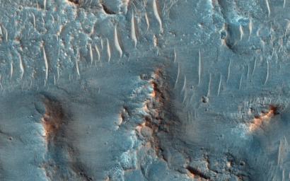
At the Head of a Kasei Valles Cataract
- Click the image above for a larger view
- Full-Res JPEG (2880 x 1800) (1.4 MB)
- Full-Res TIFF (2880 x 1800) (15.6 MB)
Caption:

Map Projected Browse Image
Click on the image for larger version
On Earth, cataracts represent regions where a river's gradient increases enough to create so much turbulence, that air gets incorporated into the water body forming a bubbly current sometimes called "whitewater". This image covers a location that may have acted as a cataract in the Kasei valley region.
This observation samples the bedrock lithologies and gives us a measure of the post-flood erosion and modification history for the floor of Kasei Valles. At high resolution, we can also look for boulders .
While there is a HiRISE stereo pair adjacent to this location that captures much of this cataract, it also misses some of the head scarp that might be the most useful, scientifically.
This caption is based on the original science rationale.
This is a stereo pair with PSP_003948_2055 .
Background Info:
The University of Arizona, Tucson, operates HiRISE, which was built by Ball Aerospace & Technologies Corp., Boulder, Colo. NASA's Jet Propulsion Laboratory, a division of the California Institute of Technology in Pasadena, manages the Mars Reconnaissance Orbiter Project for NASA's Science Mission Directorate, Washington.
Cataloging Keywords:
| Name | Value | Additional Values |
|---|---|---|
| Target | Mars | |
| System | ||
| Target Type | Planet | |
| Mission | Mars Reconnaissance Orbiter (MRO) | |
| Instrument Host | Mars Reconnaissance Orbiter | |
| Host Type | Orbiter | |
| Instrument | High Resolution Imaging Science Experiment (HiRISE) | |
| Detector | ||
| Extra Keywords | Color, Map, Water | |
| Acquisition Date | ||
| Release Date | 2015-03-25 | |
| Date in Caption | ||
| Image Credit | NASA/JPL-Caltech/University of Arizona | |
| Source | photojournal.jpl.nasa.gov/catalog/PIA19351 | |
| Identifier | PIA19351 | |
