|
Slope Streaks on a Dusty Planet
- Click the image above for a larger view
- Full-Res JPEG (2880 x 1800) (534.2 kB)
- Full-Res TIFF (2880 x 1800) (15.6 MB)
Caption:

Map Projected Browse Image
Click on the image for larger version
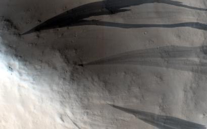
Mars is a dusty place and in some locations thick blankets of its characteristically red dust can slowly settle out of the atmosphere and accumulate on slopes. This dust is also a lot brighter than the dust-free terrain on Mars; so, if you scrape off the dust, you'll see a darker surface underneath.
This particular image shows one of these dusty areas. The dark streaks on the slopes are locations where the dust has slumped downhill revealing a less dusty surface underneath. In some cases, these slope streaks might be triggered by Marsquakes or nearby meteorite impacts. Scientists think they form quickly: more like an avalanche than dust slowly creeping downhill.
Look more closely and you'll notice that some streaks are darker than others. Dust is settling out of the atmosphere all the time and these dark streaks get slowly buried by fresh dust so that they fade back into their brighter redder surroundings. It's not certain how long this fading takes to happen, but it's probably close to a few decades.
Dust is an important player in the weather and climate on Mars. Images like this are used to monitor slow changes in these streaks over time to better understand how much dust is settling on the surface.
Background Info:
The University of Arizona, Tucson, operates HiRISE, which was built by Ball Aerospace & Technologies Corp., Boulder, Colorado. NASA's Jet Propulsion Laboratory, a division of the California Institute of Technology in Pasadena, manages the Mars Reconnaissance Orbiter Project and Mars Science Laboratory Project for NASA's Science Mission Directorate, Washington.
Cataloging Keywords:
| Name | Value | Additional Values |
|---|---|---|
| Target | Mars | |
| System | ||
| Target Type | Planet | |
| Mission | Mars Reconnaissance Orbiter (MRO) | Mars Science Laboratory (MSL) |
| Instrument Host | Mars Reconnaissance Orbiter | Curiosity Rover |
| Host Type | Orbiter | Rover |
| Instrument | High Resolution Imaging Science Experiment (HiRISE) | |
| Detector | ||
| Extra Keywords | Atmosphere, Color, Dust, Impact, Map | |
| Acquisition Date | ||
| Release Date | 2015-05-06 | |
| Date in Caption | ||
| Image Credit | NASA/JPL-Caltech/Univ. of Arizona | |
| Source | photojournal.jpl.nasa.gov/catalog/PIA19456 | |
| Identifier | PIA19456 | |
