|
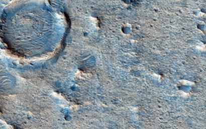
Clay-Rich Terrain in Oxia Planum: A Proposed ExoMars Landing Site
- Click the image above for a larger view
- Full-Res JPEG (2880 x 1800) (1.4 MB)
- Full-Res TIFF (2880 x 1800) (15.6 MB)
Caption:

Map Projected Browse Image
Click on the image for larger version
Oxia Planum is an ancient ( Noachian epoch ) terrain situated to the east of Chryse Planitia at about 18 degrees north. The OMEGA infrared spectrometer on board Mars Express, and CRISM onboard the Mars Reconnaissance Orbiter, have identified iron-magnesium rich clays like smectite over hundreds of square kilometers.
This image uses HiRISE to show what the surface looks like and whether it is feasible to land a rover on it. In this instance the image was taken with the ExoMars rover in mind (Oxia Planum is one of the leading candidate sites for that mission) but the Mars 2020 mission is another possibility. The image shows that the landscape is flat in this area .
The origin of the clays-perhaps due to alteration of volcanic sediments-is of keen interest to researchers looking for a terrain where traces of life have been preserved and could be studied by a rover. Another issue that rover planners have to be aware of is the presence of dunes which could block the traverses of rovers, but this part of Oxia Planum appears benign in that respect as well.
Note: "Oxia Planum" is an informal name and not an official one.
Background Info:
The University of Arizona, Tucson, operates HiRISE, which was built by Ball Aerospace & Technologies Corp., Boulder, Colorado. NASA's Jet Propulsion Laboratory, a division of the California Institute of Technology in Pasadena, manages the Mars Reconnaissance Orbiter Project and Mars Science Laboratory Project for NASA's Science Mission Directorate, Washington.
Cataloging Keywords:
| Name | Value | Additional Values |
|---|---|---|
| Target | Mars | |
| System | ||
| Target Type | Planet | |
| Mission | Mars Reconnaissance Orbiter (MRO) | Mars Express, Mars Express (MEX), Mars Science Laboratory (MSL) |
| Instrument Host | Mars Reconnaissance Orbiter | Curiosity Rover, Mars Express, Mars Express Orbiter |
| Host Type | Orbiter | Rover |
| Instrument | High Resolution Imaging Science Experiment (HiRISE) | Compact Reconnaissance Imaging Spectrometer for Mars (CRISM), Visible and Infrared Mineralogical Mapping Spectrometer (OMEGA) |
| Detector | ||
| Extra Keywords | Color, Dune, Infrared, Map, Volcano | |
| Acquisition Date | ||
| Release Date | 2015-07-01 | |
| Date in Caption | ||
| Image Credit | NASA/JPL-Caltech/Univ. of Arizona | |
| Source | photojournal.jpl.nasa.gov/catalog/PIA19851 | |
| Identifier | PIA19851 | |
