|
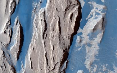
Western Medusa Fossae Formation: Dust and Dunes
- Click the image above for a larger view
- Full-Res JPEG (2880 x 1800) (734.2 kB)
- Full-Res TIFF (2880 x 1800) (15.6 MB)
Caption:

Map Projected Browse Image
Click on the image for larger version
This beautifully contrasted infrared-color image shows an area approximately 600 by 900 meters. This is a close-up of the western Medusa Fossae formation where we can see dust-covered rocky, bedrock surfaces (beige) and a bluish-tinted sand sheet that transitions into several dunes.
The bluish sand is thought to originate from the bedrock that lies beneath the dust. If true, this has implications for the composition of the formation, which has been highly debated over the years .
Background Info:
The University of Arizona, Tucson, operates HiRISE, which was built by Ball Aerospace & Technologies Corp., Boulder, Colo. NASA's Jet Propulsion Laboratory, a division of the California Institute of Technology in Pasadena, manages the Mars Reconnaissance Orbiter Project for NASA's Science Mission Directorate, Washington.
Cataloging Keywords:
| Name | Value | Additional Values |
|---|---|---|
| Target | Mars | |
| System | ||
| Target Type | Planet | |
| Mission | Mars Reconnaissance Orbiter (MRO) | |
| Instrument Host | Mars Reconnaissance Orbiter | |
| Host Type | Orbiter | |
| Instrument | High Resolution Imaging Science Experiment (HiRISE) | |
| Detector | ||
| Extra Keywords | Color, Dune, Dust, Infrared, Map | |
| Acquisition Date | ||
| Release Date | 2015-09-16 | |
| Date in Caption | ||
| Image Credit | NASA/JPL-Caltech/Univ. of Arizona | |
| Source | photojournal.jpl.nasa.gov/catalog/PIA19939 | |
| Identifier | PIA19939 | |
