|
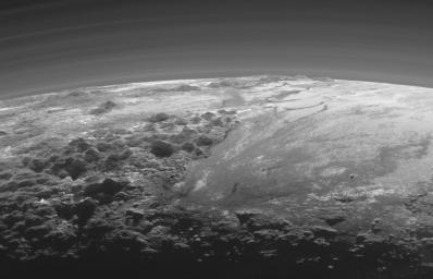
Closer Look: Majestic Mountains and Frozen Plains
- Click the image above for a larger view
- Full-Res JPEG (2055 x 1321) (226.5 kB)
- Full-Res TIFF (2055 x 1321) (2.0 MB)
Caption:
Just 15 minutes after its closest approach to Pluto on July 14, 2015, NASA's New Horizons spacecraft looked back toward the sun and captured a near-sunset view of the rugged, icy mountains and flat ice plains extending to Pluto's horizon. The smooth expanse of the informally named Sputnik Planum (right) is flanked to the west (left) by rugged mountains up to 11,000 feet (3,500 meters) high, including the informally named Norgay Montes in the foreground and Hillary Montes on the skyline. The backlighting highlights more than a dozen layers of haze in Pluto's tenuous but distended atmosphere. The image was taken from a distance of 11,000 miles (18,000 kilometers) to Pluto; the scene is 230 miles (380 kilometers) across.
Background Info:
The Johns Hopkins University Applied Physics Laboratory in Laurel, Maryland, designed, built, and operates the New Horizons spacecraft, and manages the mission for NASA's Science Mission Directorate. The Southwest Research Institute, based in San Antonio, leads the science team, payload operations and encounter science planning. New Horizons is part of the New Frontiers Program managed by NASA's Marshall Space Flight Center in Huntsville, Alabama.
Cataloging Keywords:
| Name | Value | Additional Values |
|---|---|---|
| Target | Pluto | |
| System | Pluto | Kuiper Belt |
| Target Type | Dwarf Planet | KBO |
| Mission | New Horizons | |
| Instrument Host | New Horizons | |
| Host Type | Flyby Spacecraft | |
| Instrument | Multispectral Visible Imaging Camera (MVIC) | |
| Detector | ||
| Extra Keywords | Atmosphere, Grayscale, Haze, Mountain | |
| Acquisition Date | ||
| Release Date | 2015-09-17 | |
| Date in Caption | 2015-07-14 | |
| Image Credit | NASA/Johns Hopkins University Applied Physics Laboratory/Southwest Research Institute | |
| Source | photojournal.jpl.nasa.gov/catalog/PIA19947 | |
| Identifier | PIA19947 | |
