
|
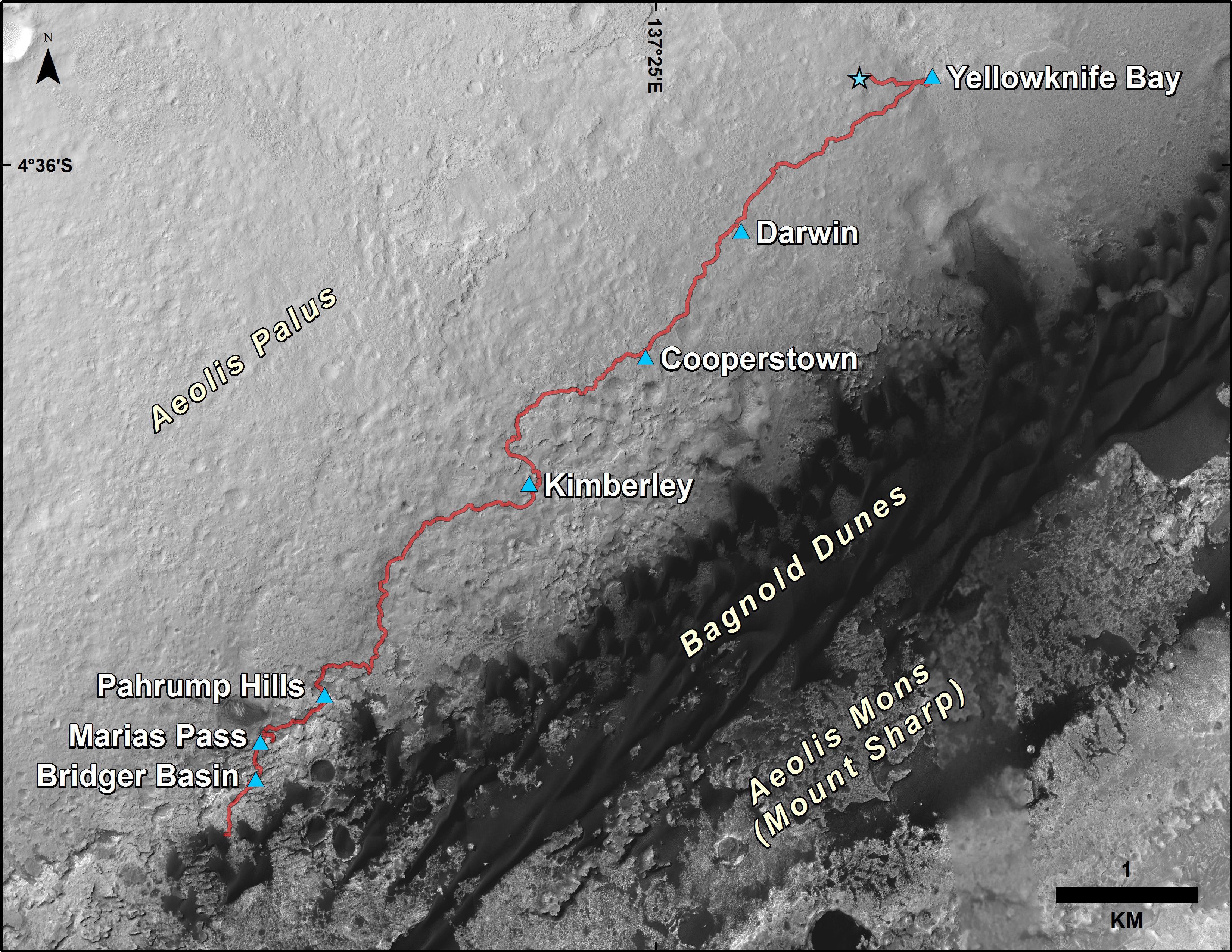
Curiosity Rover’s Traverse, First 1,185 Sols on Mars
- Click the image above for a larger view
- Full-Res JPEG (3300 x 2550) (1.5 MB)
- Full-Res TIFF (3300 x 2550) (13.3 MB)
Caption:
This map shows the route driven by NASA's Curiosity Mars rover from the location where it landed in August 2012 to its location in December 2015, at examples of the "Bagnold Dunes." The mission's investigation targets in the "Marias Pass" and "Bridger Basin" areas included rocks with compositions high in silica.
The traverse line covers drives completed through the 1,185th Martian day, or sol, of Curiosity's work on Mars (Dec. 6, 2015).
The base image for this map is from the High Resolution Imaging Science Experiment (HiRISE) camera on NASA's Mars Reconnaissance Orbiter. North is up. Bagnold Dunes form a band of dark, wind-blown material at the foot of Mount Sharp.
The scale bar at lower right represents one kilometer (0.62 mile). For broader-context images of the area, see PIA17355 , PIA16064 and PIA16058 .
Background Info:
NASA's Jet Propulsion Laboratory, a division of the California Institute of Technology, Pasadena, manages the Mars Science Laboratory Project and Mars Reconnaissance Orbiter Project for NASA's Science Mission Directorate, Washington. For more information about the Mars Science Laboratory mission and the mission's Curiosity rover, visit http://www.nasa.gov/msl and http://mars.jpl.nasa.gov/msl .
Cataloging Keywords:
| Name | Value | Additional Values |
|---|---|---|
| Target | Mars | |
| System | ||
| Target Type | Planet | |
| Mission | Mars Reconnaissance Orbiter (MRO) | Mars Science Laboratory (MSL) |
| Instrument Host | Mars Reconnaissance Orbiter | Curiosity Rover |
| Host Type | Orbiter | Rover |
| Instrument | High Resolution Imaging Science Experiment (HiRISE) | |
| Detector | ||
| Extra Keywords | Color, Dune, Map | |
| Acquisition Date | ||
| Release Date | 2015-12-17 | |
| Date in Caption | 2015-12-06 | |
| Image Credit | NASA/JPL-Caltech/Univ. of Arizona | |
| Source | photojournal.jpl.nasa.gov/catalog/PIA20172 | |
| Identifier | PIA20172 | |