|
Surface Diversity
- Click the image above for a larger view
- Full-Res JPEG (2042 x 1006) (411.7 kB)
- Full-Res TIFF (2042 x 1006) (6.2 MB)
Caption:
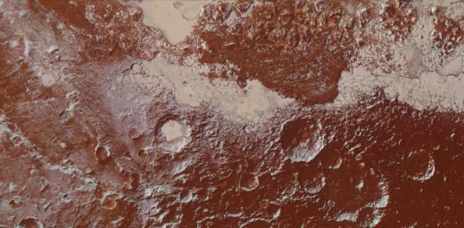
This enhanced color view of Pluto's surface diversity was created by merging Ralph/Multispectral Visible Imaging Camera (MVIC) color imagery (650 meters per pixel) with Long Range Reconnaissance Imager panchromatic imagery (230 meters per pixel). At lower right, ancient, heavily cratered terrain is coated with dark, reddish tholins. At upper right, volatile ices filling the informally named Sputnik Planum have modified the surface, creating a chaos-like array of blocky mountains. Volatile ice also occupies a few nearby deep craters, and in some areas the volatile ice is pocked with arrays of small sublimation pits. At left, and across the bottom of the scene, gray-white CH4 ice deposits modify tectonic ridges, the rims of craters, and north-facing slopes. The scene in this image is 260 miles (420 kilometers) wide and 140 miles (225 kilometers) from top to bottom; north is to the upper left.
Background Info:
The Johns Hopkins University Applied Physics Laboratory in Laurel, Maryland, designed, built, and operates the New Horizons spacecraft, and manages the mission for NASA's Science Mission Directorate. The Southwest Research Institute, based in San Antonio, leads the science team, payload operations and encounter science planning. New Horizons is part of the New Frontiers Program managed by NASA's Marshall Space Flight Center in Huntsville, Alabama.
Cataloging Keywords:
| Name | Value | Additional Values |
|---|---|---|
| Target | Pluto | |
| System | Pluto | Kuiper Belt |
| Target Type | Dwarf Planet | KBO |
| Mission | New Horizons | |
| Instrument Host | New Horizons | |
| Host Type | Flyby Spacecraft | |
| Instrument | Long Range Reconnaissance Imager (LORRI) | Multispectral Visible Imaging Camera (MVIC) |
| Detector | ||
| Extra Keywords | Color, Crater, Mountain, Visual | |
| Acquisition Date | ||
| Release Date | 2016-03-17 | |
| Date in Caption | ||
| Image Credit | NASA/Johns Hopkins University Applied Physics Laboratory/Southwest Research Institute | |
| Source | photojournal.jpl.nasa.gov/catalog/PIA20534 | |
| Identifier | PIA20534 | |
