|
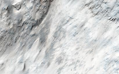
A Boulder Festival in Masursky Crater
- Click the image above for a larger view
- Full-Res JPEG (2880 x 1800) (791.1 kB)
- Full-Res TIFF (2880 x 1800) (14.5 MB)
Caption:

Map Projected Browse Image
Click on the image for larger version
This image covers part of the chaotic terrain in Masursky Crater, and was targeted due to evidence that ejecta from Mojave Crater -- to the south -- may have modified the landscape. Mojave Crater may be the most recent large (more than 50-kilometer wide) impact crater on Mars, and produced some remarkable fluvial (water-carved) landscapes.
In Masursky Crater we see huge numbers of boulder trails. These appear as dashed lines produced by boulders tumbling down steep slopes, periodically gouging troughs in the ground . Why are there so many boulder trails here? Possibly the ejecta from Mojave Crater disturbed the surface and sent the boulders tumbling downhill.
Background Info:
The University of Arizona, Tucson, operates HiRISE, which was built by Ball Aerospace & Technologies Corp., Boulder, Colo. NASA's Jet Propulsion Laboratory, a division of the California Institute of Technology in Pasadena, manages the Mars Reconnaissance Orbiter Project for NASA's Science Mission Directorate, Washington.
Cataloging Keywords:
| Name | Value | Additional Values |
|---|---|---|
| Target | Mars | |
| System | ||
| Target Type | Planet | |
| Mission | Mars Reconnaissance Orbiter (MRO) | |
| Instrument Host | Mars Reconnaissance Orbiter | |
| Host Type | Orbiter | |
| Instrument | High Resolution Imaging Science Experiment (HiRISE) | |
| Detector | ||
| Extra Keywords | Crater, Impact, Map, Rotation, Water | |
| Acquisition Date | ||
| Release Date | 2016-04-06 | |
| Date in Caption | ||
| Image Credit | NASA/JPL-Caltech/Univ. of Arizona | |
| Source | photojournal.jpl.nasa.gov/catalog/PIA20550 | |
| Identifier | PIA20550 | |
