
|
Pluto: A Global Perspective
- Click the image above for a larger view
- Full-Res JPEG (2400 x 1200) (212.2 kB)
- Full-Res TIFF (2400 x 1200) (1.7 MB)
Caption:
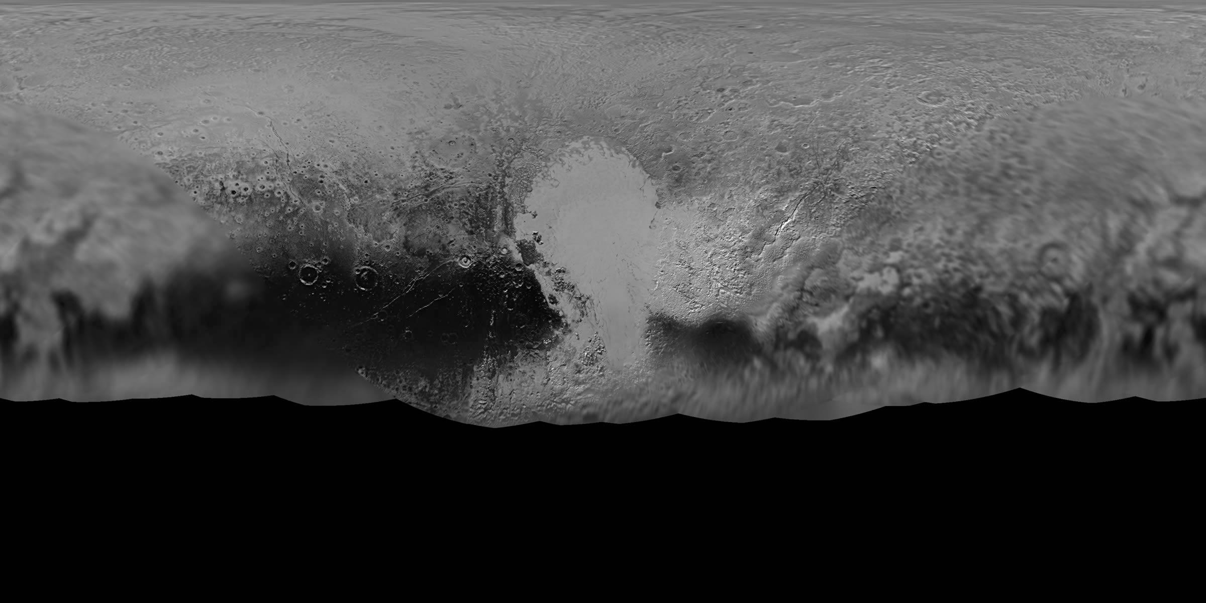
NASA's New Horizons mission science team has produced this updated panchromatic (black-and-white) global map of Pluto. The map includes all resolved images of Pluto's surface acquired between July 7-14, 2015, at pixel resolutions ranging from 18 miles (30 kilometers) on the Charon-facing hemisphere (left and right edges of the map) to 770 feet (235 meters) on the hemisphere facing New Horizons during the spacecraft's closest approach on July 14, 2015 (map center). The non-encounter hemisphere was seen from much greater range and is, therefore, in far less detail.
The latest images woven into the map were sent back to Earth as recently as April 25, and the team will continue to add photos as the spacecraft transmits the rest of its stored Pluto encounter data. All encounter imagery is expected on Earth by early fall. The team is also working on improved color maps.
Background Info:
The Johns Hopkins University Applied Physics Laboratory in Laurel, Maryland, designed, built, and operates the New Horizons spacecraft, and manages the mission for NASA's Science Mission Directorate. The Southwest Research Institute, based in San Antonio, leads the science team, payload operations and encounter science planning. New Horizons is part of the New Frontiers Program managed by NASA's Marshall Space Flight Center in Huntsville, Alabama.
Cataloging Keywords:
| Name | Value | Additional Values |
|---|---|---|
| Target | Pluto | Charon |
| System | Pluto | Kuiper Belt |
| Target Type | Satellite | Dwarf Planet, KBO |
| Mission | New Horizons | |
| Instrument Host | New Horizons | |
| Host Type | Flyby Spacecraft | |
| Instrument | Long Range Reconnaissance Imager (LORRI) | |
| Detector | ||
| Extra Keywords | Grayscale, Map | |
| Acquisition Date | ||
| Release Date | 2016-05-02 | |
| Date in Caption | 2015-07-14 | |
| Image Credit | NASA/Johns Hopkins University Applied Physics Laboratory/Southwest Research Institute | |
| Source | photojournal.jpl.nasa.gov/catalog/PIA20658 | |
| Identifier | PIA20658 | |