
|
Radargrams Indicating Ice-Rich Subsurface Deposit
- Click the image above for a larger view
- Full-Res JPEG (602 x 122) (21.3 kB)
- Full-Res TIFF (602 x 122) (73.7 kB)
Caption:
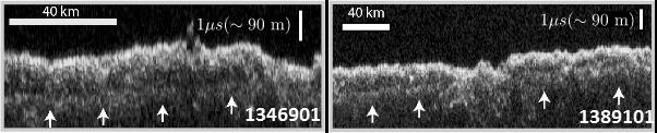
These two images show data acquired by the Shallow Radar (SHARAD) instrument while passing over two ground tracks in a part of Mars' Utopia Planitia region where the orbiting, ground-penetrating radar detected subsurface deposits rich in water ice.
The instrument on NASA's Mars Reconnaissance Orbiter emits radio waves and times their echo off of radio-reflective surfaces and interfaces on Mars. The white arrows indicate a subsurface reflector interpreted as the bottom of the ice-rich deposit. The deposit is about as large in area as the state of New Mexico and contains about as much water as Lake Superior.
The horizontal scale bar indicates 40 kilometers (25 miles) along the ground track of the radar, as flown by the orbiter overhead. The vertical scale bar indicates a return time of one microsecond for the reflected radio signal, equivalent to a distance of about 90 meters (295 feet).
Background Info:
SHARAD was provided by the Italian Space Agency. Its operations are led by Sapienza University of Rome, and its data are analyzed by a joint U.S.-Italian science team. The Planetary Science Institute, Tucson, Arizona, leads U.S. involvement in SHARAD. NASA's Jet Propulsion Laboratory, a division of Caltech in Pasadena, California, manages the Mars Reconnaissance Orbiter for the NASA Science Mission Directorate, Washington. Lockheed Martin Space Systems, Denver, built the orbiter and supports its operations.
Cataloging Keywords:
| Name | Value | Additional Values |
|---|---|---|
| Target | Mars | |
| System | ||
| Target Type | Planet | |
| Mission | Mars Reconnaissance Orbiter (MRO) | |
| Instrument Host | Mars Reconnaissance Orbiter | |
| Host Type | Orbiter | |
| Instrument | Shallow Subsurface Radar (SHARAD) | |
| Detector | ||
| Extra Keywords | Grayscale, Radar, Radio, Water | |
| Acquisition Date | ||
| Release Date | 2016-11-22 | |
| Date in Caption | ||
| Image Credit | NASA/JPL-Caltech/Univ. of Rome/ASI/PSI | |
| Source | photojournal.jpl.nasa.gov/catalog/PIA21137 | |
| Identifier | PIA21137 | |